Meïganga geodata
Meïganga (Adamaoua) is a populated place; located in Cameroon in Africa/Douala (GMT+1) time zone. With population of 80,100 people, there are 23 cities with bigger population in this country. Compared to other cities in Cameroon, 81.1% of cities are located further ↓South; 89.3% of cities are located further ←West and 73.8% of cities have lower elevation than Meïganga. Note1


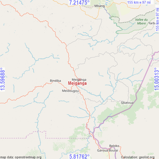
Meïganga GPS coordinates[2]
6° 31' 0.012" North, 14° 18' 0" East
| Map corner | latitude | longitude |
|---|---|---|
| Upper-left | 7.21475°, | 13.59688° |
| Center: | 6.51667°, | 14.3° |
| Lower-right: | 5.81762°, | 15.00313° |
| Map W x H: | 155.3×155.4 km | = 96.5×96.6mi |
| max Lat: | 12.57535° ⇑18.9% North |
| Meïganga: | 6.51667° |
| min Lat: | ⇓81.1% South 2.35° |
| min Long | Meïganga | max Long |
| 8.8724° | 14.3° | 15.23288° |
| W 89.3%⇐ | ⇒10.7% E |
Elevation
Elevation of Meïganga is 970 m = 3182 ft, and this is 296.1 m = 971 ft above average elevation for this country.
| Max E: |
1687 m = 5535 ft | 26.2% |
| Meïganga | 970 m 3182 ft | |
| Avg. | 673.9 m = 2211 ft | |
Min E: |
1 m = 3 ft | 73.8% |
See also: Meïganga elevation on elevation.city.
Geographical zone
Meïganga is located in North Torrid zone (between Equator and Tropic of Cancer). Distance of Equator is 724.6 km =450.2 mi to South.| Distance of | km | miles | from Meïganga |
|---|---|---|---|
| North Pole | 9282.5 | 5767.9 | to North |
| Arctic Circle | 6676.6 | 4148.6 | to North |
| Tropic Cancer | 1881.3 | 1169 | to North |
| Equator | 724.6 | 450.2 | to South |


Nearby cities:
15 places around Meïganga: (largest is in red/bold)
• Batouri
231.8 km =144 mi,  178°
178°
• Bertoua
226.1 km =140.5 mi,  197°
197°
• Bélabo
207.9 km =129.2 mi,  212°
212°
• Bélel
61.1 km =38 mi,  13°
13°
• Bétaré Oya
104.7 km =65.1 mi,  193°
193°
• Djohong
56.5 km =35.1 mi,  51°
51°
• Garoua Boulaï
75.6 km =47 mi,  158°
158°
• Mbang
240.1 km =149.2 mi, 206°
• Ngaoundéré
119.9 km =74.5 mi,  318°
318°
• Poli
247.1 km =153.5 mi,  331°
331°
• Rey Bouba
240.1 km =149.2 mi,  356°
356°
• Tcholliré
210.1 km =130.6 mi, 356°
• Tibati
184.8 km =114.8 mi,  268°
268°
• Tignère
205.2 km =127.5 mi,  297°
297°
• Yoko
245 km =152.2 mi,  243°
243°
Sources, notices
• [Note1] Compared only with cities in Cameroon existing in our database
• [Src1] Map data: © OpenStreetMap contributors (CC-BY-SA)
• [Src2] Other city data from geonames.org with taken over terms of usage.
• [Src3] Geographical zone / Annual Mean Temperature by Robert A. Rohde @ Wikipedia
