Tcholliré geodata
Tcholliré (North) is a populated place; located in Cameroon in Africa/Douala (GMT+1) time zone. With population of 23,187 people, there are 54 cities with bigger population in this country. Compared to other cities in Cameroon, 86.9% of cities are located further ↓South; 87.7% of cities are located further ←West and 73% of cities have higher elevation than Tcholliré. Note1


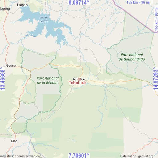
Tcholliré GPS coordinates[2]
8° 24' 7.92" North, 14° 10' 11.28" East
| Map corner | latitude | longitude |
|---|---|---|
| Upper-left | 9.09714°, | 13.46668° |
| Center: | 8.4022°, | 14.1698° |
| Lower-right: | 7.70601°, | 14.87293° |
| Map W x H: | 154.7×154.7 km | = 96.1×96.1mi |
| max Lat: | 12.57535° ⇑13.1% North |
| Tcholliré: | 8.4022° |
| min Lat: | ⇓86.9% South 2.35° |
| min Long | Tcholliré | max Long |
| 8.8724° | 14.1698° | 15.23288° |
| W 87.7%⇐ | ⇒12.3% E |
Elevation
Elevation of Tcholliré is 382 m = 1253 ft, and this is 291.9 m = 958 ft below average elevation for this country.
| Max E: |
1687 m = 5535 ft | 73% |
| Avg. | 673.9 m = 2211 ft | |
| Tcholliré | 382 m = 1253 ft | |
Min E: |
1 m = 3 ft | 27% |
See also: Cameroon elevation on elevation.city.
Geographical zone
Tcholliré is located in North Torrid zone (between Equator and Tropic of Cancer). Distance of Equator is 934.2 km =580.5 mi to South.| Distance of | km | miles | from Tcholliré |
|---|---|---|---|
| North Pole | 9072.8 | 5637.6 | to North |
| Arctic Circle | 6466.9 | 4018.3 | to North |
| Tropic Cancer | 1671.7 | 1038.7 | to North |
| Equator | 934.2 | 580.5 | to South |


Nearby cities:
15 places around Tcholliré: (largest is in red/bold)
• Bélel
153.1 km =95.1 mi,  169°
169°
• Djohong
184 km =114.3 mi,  161°
161°
• Garoua
131.1 km =81.5 mi,  319°
319°
• Guider
172 km =106.9 mi,  351°
351°
• Kaélé
192.3 km =119.5 mi,  9°
9°
• Kontcha
218.6 km =135.8 mi,  257°
257°
• Lagdo
91.6 km =56.9 mi, 322°
• Maroua
243.9 km =151.6 mi,  3°
3°
• Meïganga
210.1 km =130.6 mi,  176°
176°
• Mindif
223.8 km =139.1 mi, 7°
• Ngaoundéré
135.7 km =84.3 mi,  208°
208°
• Pitoa
131.5 km =81.7 mi,  326°
326°
• Poli
102.5 km =63.7 mi,  274°
274°
• Rey Bouba
30.1 km =18.7 mi, 1°
• Tignère
203.2 km =126.3 mi,  235°
235°
Sources, notices
• [Note1] Compared only with cities in Cameroon existing in our database
• [Src1] Map data: © OpenStreetMap contributors (CC-BY-SA)
• [Src2] Other city data from geonames.org with taken over terms of usage.
• [Src3] Geographical zone / Annual Mean Temperature by Robert A. Rohde @ Wikipedia
