Poli geodata
Poli (North) is a populated place; located in Cameroon in Africa/Douala (GMT+1) time zone. With population of 5,727 people, there are 93 cities with bigger population in this country. Compared to other cities in Cameroon, 87.7% of cities are located further ↓South; 75.4% of cities are located further ←West and 66.4% of cities have higher elevation than Poli. Note1


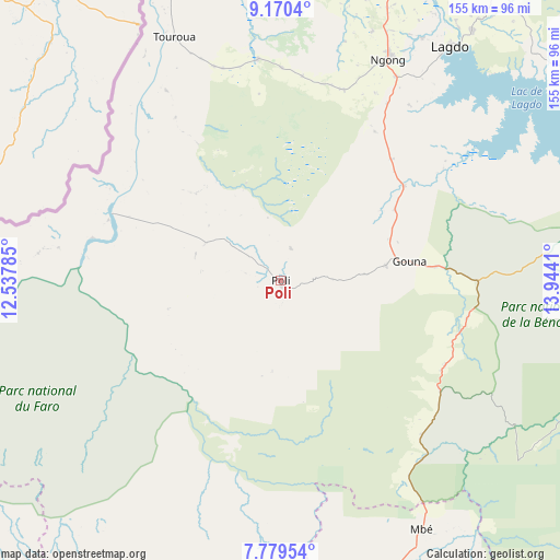
Poli GPS coordinates[2]
8° 28' 32.16" North, 13° 14' 27.492" East
| Map corner | latitude | longitude |
|---|---|---|
| Upper-left | 9.1704°, | 12.53785° |
| Center: | 8.4756°, | 13.24097° |
| Lower-right: | 7.77954°, | 13.9441° |
| Map W x H: | 154.6×154.7 km | = 96.1×96.1mi |
| max Lat: | 12.57535° ⇑12.3% North |
| Poli: | 8.4756° |
| min Lat: | ⇓87.7% South 2.35° |
| min Long | Poli | max Long |
| 8.8724° | 13.24097° | 15.23288° |
| W 75.4%⇐ | ⇒24.6% E |
Elevation
Elevation of Poli is 477 m = 1565 ft, and this is 196.9 m = 646 ft below average elevation for this country.
| Max E: |
1687 m = 5535 ft | 66.4% |
| Avg. | 673.9 m = 2211 ft | |
| Poli | 477 m = 1565 ft | |
Min E: |
1 m = 3 ft | 33.6% |
See also: Cameroon elevation on elevation.city.
Geographical zone
Poli is located in North Torrid zone (between Equator and Tropic of Cancer). Distance of Equator is 942.4 km =585.6 mi to South.| Distance of | km | miles | from Poli |
|---|---|---|---|
| North Pole | 9064.7 | 5632.5 | to North |
| Arctic Circle | 6458.8 | 4013.3 | to North |
| Tropic Cancer | 1663.5 | 1033.7 | to North |
| Equator | 942.4 | 585.6 | to South |


Nearby cities:
15 places around Poli: (largest is in red/bold)
• Banyo
247.9 km =154 mi,  219°
219°
• Bélel
205.9 km =127.9 mi,  140°
140°
• Djohong
243.3 km =151.2 mi, 138°
• Garoua
93.4 km =58 mi,  10°
10°
• Guider
179.6 km =111.6 mi,  25°
25°
• Kaélé
225 km =139.8 mi,  36°
36°
• Kontcha
124.5 km =77.4 mi,  242°
242°
• Lagdo
79.9 km =49.6 mi, 35°
• Meïganga
247.1 km =153.5 mi,  151°
151°
• Ngaoundéré
133.1 km =82.7 mi,  163°
163°
• Pitoa
105 km =65.2 mi,  15°
15°
• Rey Bouba
105.4 km =65.5 mi,  78°
78°
• Tcholliré
102.5 km =63.7 mi,  94°
94°
• Tibati
233.5 km =145.1 mi,  196°
196°
• Tignère
139.4 km =86.6 mi,  207°
207°
Sources, notices
• [Note1] Compared only with cities in Cameroon existing in our database
• [Src1] Map data: © OpenStreetMap contributors (CC-BY-SA)
• [Src2] Other city data from geonames.org with taken over terms of usage.
• [Src3] Geographical zone / Annual Mean Temperature by Robert A. Rohde @ Wikipedia
