Santa Rosa geodata
Santa Rosa (El Oro) is a populated place; located in Ecuador in America/Guayaquil (GMT-5) time zone. With population of 41,816 people, there are 28 cities with bigger population in this country. Compared to other cities in Ecuador, 90.1% of cities are located further ↑North; 74.4% of cities are located further →East and 86% of cities have higher elevation than Santa Rosa. Note1


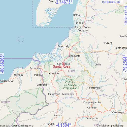
Santa Rosa GPS coordinates[2]
3° 26' 55.752" South, 79° 57' 34.272" West
| Map corner | latitude | longitude |
|---|---|---|
| Upper-left | -2.74673°, | -80.66265° |
| Center: | -3.44882°, | -79.95952° |
| Lower-right: | -4.1504°, | -79.2564° |
| Map W x H: | 156.1×156.1 km | = 97×97mi |
| max Lat: | 1.35251° ⇑90.1% North |
| Santa Rosa: | -3.44882° |
| min Lat: | ⇓9.9% South -4.38181° |
| min Long | Santa Rosa | max Long |
| -90.96654° | -79.95952° | -76.89528° |
| W 25.6%⇐ | ⇒74.4% E |
Elevation
Elevation of Santa Rosa is 11 m = 36 ft, and this is 934.1 m = 3065 ft below average elevation for this country.
| Max E: |
3131 m = 10272 ft | 86% |
| Avg. | 945.1 m = 3101 ft | |
| Santa Rosa | 11 m = 36 ft | |
Min E: |
1 m = 3 ft | 14% |
See also: Santa Rosa elevation on elevation.city.
Geographical zone
Santa Rosa is located in South Torrid zone (between Equator and Tropic of Capricorn). Distance of Equator is 383.5 km =238.3 mi to North.| Distance of | km | miles | from Santa Rosa |
|---|---|---|---|
| Equator | 383.5 | 238.3 | to North |
| Tropic Capricorn | 2222.4 | 1380.9 | to South |
| Antarctic Circle | 7017.7 | 4360.6 | to South |
| South Pole | 9623.6 | 5979.8 | to South |


Nearby cities:
15 places around Santa Rosa: (largest is in red/bold)
• Baláo
61.9 km =38.5 mi,  15°
15°
• Catacocha
75.2 km =46.7 mi,  152°
152°
• Catamayo
89.5 km =55.6 mi,  131°
131°
• Celica
72.7 km =45.2 mi,  179°
179°
• Huaquillas
30.3 km =18.8 mi,  264°
264°
• Loja
103.4 km =64.2 mi, 125°
• Macará
103.8 km =64.5 mi, 179°
• Machala
21.1 km =13.1 mi,  359°
359°
• Naranjal
94.2 km =58.5 mi, 23°
• Pasaje
21.8 km =13.5 mi,  51°
51°
• Piñas
40.3 km =25 mi, 129°
• Playas
102.5 km =63.7 mi,  332°
332°
• Portovelo
48.2 km =30 mi, 128°
• Puerto Bolívar
20.7 km =12.9 mi,  348°
348°
• Zaruma
47.1 km =29.3 mi,  124°
124°
Sources, notices
• [Note1] Compared only with cities in Ecuador existing in our database
• [Src1] Map data: © OpenStreetMap contributors (CC-BY-SA)
• [Src2] Other city data from geonames.org with taken over terms of usage.
• [Src3] Geographical zone / Annual Mean Temperature by Robert A. Rohde @ Wikipedia
