Celica geodata
Celica (Loja) is a populated place; located in Ecuador in America/Guayaquil (GMT-5) time zone. With population of 5,499 people, there are 103 cities with bigger population in this country. Compared to other cities in Ecuador, 98.3% of cities are located further ↑North; 73.6% of cities are located further →East and 71.9% of cities have lower elevation than Celica. Note1


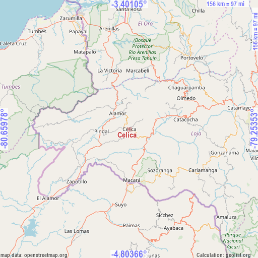
Celica GPS coordinates[2]
4° 6' 9.576" South, 79° 57' 23.94" West
| Map corner | latitude | longitude |
|---|---|---|
| Upper-left | -3.40105°, | -80.65978° |
| Center: | -4.10266°, | -79.95665° |
| Lower-right: | -4.80366°, | -79.25353° |
| Map W x H: | 156×156 km | = 96.9×96.9mi |
| max Lat: | 1.35251° ⇑98.3% North |
| Celica: | -4.10266° |
| min Lat: | ⇓1.7% South -4.38181° |
| min Long | Celica | max Long |
| -90.96654° | -79.95665° | -76.89528° |
| W 26.4%⇐ | ⇒73.6% E |
Elevation
Elevation of Celica is 2003 m = 6572 ft, and this is 1057.9 m = 3471 ft above average elevation for this country.
| Max E: |
3131 m = 10272 ft | 28.1% |
| Celica | 2003 m 6572 ft | |
| Avg. | 945.1 m = 3101 ft | |
Min E: |
1 m = 3 ft | 71.9% |
See also: Ecuador elevation on elevation.city.
Geographical zone
Celica is located in South Torrid zone (between Equator and Tropic of Capricorn). Distance of Equator is 456.2 km =283.5 mi to North.| Distance of | km | miles | from Celica |
|---|---|---|---|
| Equator | 456.2 | 283.5 | to North |
| Tropic Capricorn | 2149.7 | 1335.8 | to South |
| Antarctic Circle | 6945 | 4315.4 | to South |
| South Pole | 9550.9 | 5934.7 | to South |


Nearby cities:
15 places around Celica: (largest is in red/bold)
• Baláo
133.4 km =82.9 mi,  6°
6°
• Cariamanga
51 km =31.7 mi,  119°
119°
• Catacocha
34.6 km =21.5 mi,  80°
80°
• Catamayo
67.5 km =41.9 mi, 78°
• Huaquillas
76.1 km =47.3 mi,  336°
336°
• Loja
84.3 km =52.4 mi, 81°
• Macará
31.1 km =19.3 mi,  177°
177°
• Machala
93.9 km =58.3 mi,  359°
359°
• Pasaje
88 km =54.7 mi, 10°
• Piñas
56 km =34.8 mi,  33°
33°
• Portovelo
56.4 km =35 mi,  41°
41°
• Puerto Bolívar
93.1 km =57.8 mi, 357°
• Santa Rosa
72.7 km =45.2 mi, 359°
• Zamora
111.2 km =69.1 mi,  87°
87°
• Zaruma
59.6 km =37 mi, 39°
Sources, notices
• [Note1] Compared only with cities in Ecuador existing in our database
• [Src1] Map data: © OpenStreetMap contributors (CC-BY-SA)
• [Src2] Other city data from geonames.org with taken over terms of usage.
• [Src3] Geographical zone / Annual Mean Temperature by Robert A. Rohde @ Wikipedia
