Saint Catherine geodata
Saint Catherine (South Sinai) is a populated place; located in Egypt in Africa/Cairo (GMT+2) time zone. With population of 4,603 people, there are 131 cities with bigger population in this country. Compared to other cities in Egypt, 67.4% of cities are located further ↑North; 94.2% of cities are located further ←West and 100% of cities have lower elevation than Saint Catherine. Note1


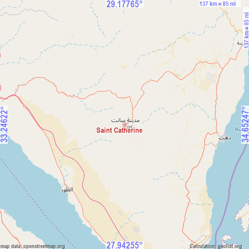
Saint Catherine GPS coordinates[2]
28° 33' 42.876" North, 33° 56' 57.624" East
| Map corner | latitude | longitude |
|---|---|---|
| Upper-left | 29.17765°, | 33.24622° |
| Center: | 28.56191°, | 33.94934° |
| Lower-right: | 27.94255°, | 34.65247° |
| Map W x H: | 137.3×137.3 km | = 85.3×85.3mi |
| max Lat: | 31.5084° ⇑67.4% North |
| Saint Catherine: | 28.56191° |
| min Lat: | ⇓32.6% South 22.3457° |
| min Long | Saint Catherine | max Long |
| 25.51965° | 33.94934° | 34.89572° |
| W 94.2%⇐ | ⇒5.8% E |
Elevation
Elevation of Saint Catherine is 1565 m = 5135 ft, and this is 1521.5 m = 4992 ft above average elevation for this country.
| Max E: |
1565 m = 5135 ft | 0% |
| Saint Catherine | 1565 m 5135 ft | |
| Avg. | 43.5 m = 143 ft | |
Min E: |
-15 m = -49 ft | 100% |
See also: Egypt elevation on elevation.city.
Geographical zone
Saint Catherine is located in North temperate zone (between Tropic of Cancer and the Arctic Circle). Distance of this Northern Tropic circle is 569.9 km =354.1 mi to South.| Distance of | km | miles | from Saint Catherine |
|---|---|---|---|
| North Pole | 6831.3 | 4244.8 | to North |
| Arctic Circle | 4225.4 | 2625.5 | to North |
| Tropic Cancer | 569.9 | 354.1 | to South |
| Equator | 3175.8 | 1973.4 | to South |


Nearby cities:
15 places around Saint Catherine: (largest is in red/bold)
• Ain Sukhna
196.2 km =121.9 mi,  306°
306°
• Al Quşayr
275.2 km =171 mi,  173°
173°
• Al Wāsiţah
280.5 km =174.3 mi,  287°
287°
• Dahab
54 km =33.6 mi,  99°
99°
• El Gouna
132.5 km =82.3 mi,  191°
191°
• El-Tor
47.9 km =29.8 mi,  221°
221°
• Hurghada
145.7 km =90.5 mi, 185°
• Ismailia
279 km =173.4 mi,  324°
324°
• Makadi Bay
174.7 km =108.6 mi,  181°
181°
• Nuwaybi‘a
88 km =54.7 mi,  52°
52°
• Ras Gharib
88.1 km =54.7 mi,  255°
255°
• Safaga
201.6 km =125.3 mi, 180°
• Sharm el-Sheikh
80.9 km =50.3 mi,  152°
152°
• Suez
209 km =129.9 mi, 318°
• Taba
138.4 km =86 mi,  41°
41°
Sources, notices
• [Note1] Compared only with cities in Egypt existing in our database
• [Src1] Map data: © OpenStreetMap contributors (CC-BY-SA)
• [Src2] Other city data from geonames.org with taken over terms of usage.
• [Src3] Geographical zone / Annual Mean Temperature by Robert A. Rohde @ Wikipedia
