Dahab geodata
Dahab (South Sinai) is a populated place; located in Egypt in Africa/Cairo (GMT+2) time zone. With population of 8,000 people, there are 125 cities with bigger population in this country. Compared to other cities in Egypt, 68.8% of cities are located further ↑North; 97.8% of cities are located further ←West and 68.1% of cities have higher elevation than Dahab. Note1


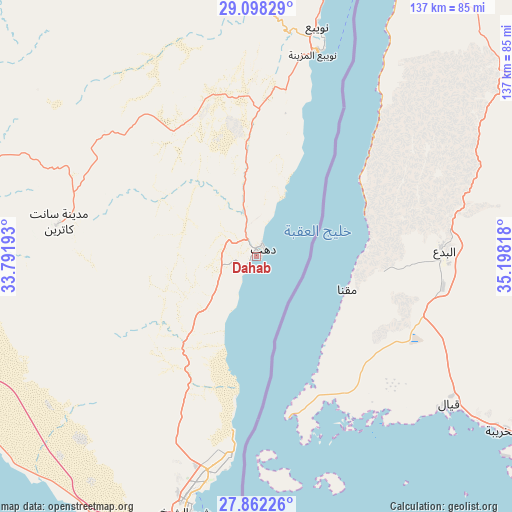
Dahab GPS coordinates[2]
28° 28' 55.488" North, 34° 29' 42.18" East
| Map corner | latitude | longitude |
|---|---|---|
| Upper-left | 29.09829°, | 33.79193° |
| Center: | 28.48208°, | 34.49505° |
| Lower-right: | 27.86226°, | 35.19818° |
| Map W x H: | 137.4×137.4 km | = 85.4×85.4mi |
| max Lat: | 31.5084° ⇑68.8% North |
| Dahab: | 28.48208° |
| min Lat: | ⇓31.2% South 22.3457° |
| min Long | Dahab | max Long |
| 25.51965° | 34.49505° | 34.89572° |
| W 97.8%⇐ | ⇒2.2% E |
Elevation
Elevation of Dahab is 13 m = 43 ft, and this is 30.5 m = 100 ft below average elevation for this country.
| Max E: |
1565 m = 5135 ft | 68.1% |
| Avg. | 43.5 m = 143 ft | |
| Dahab | 13 m = 43 ft | |
Min E: |
-15 m = -49 ft | 31.9% |
See also: Egypt elevation on elevation.city.
Geographical zone
Dahab is located in North temperate zone (between Tropic of Cancer and the Arctic Circle). Distance of this Northern Tropic circle is 561 km =348.6 mi to South.| Distance of | km | miles | from Dahab |
|---|---|---|---|
| North Pole | 6840.2 | 4250.3 | to North |
| Arctic Circle | 4234.3 | 2631.1 | to North |
| Tropic Cancer | 561 | 348.6 | to South |
| Equator | 3166.9 | 1967.8 | to South |


Nearby cities:
15 places around Dahab: (largest is in red/bold)
• Ain Sukhna
245.5 km =152.5 mi,  300°
300°
• Al Quşayr
265.3 km =164.8 mi,  184°
184°
• Arish
302.2 km =187.8 mi,  347°
347°
• Ash Shaykh Zuwayd
306.3 km =190.3 mi, 353°
• El Gouna
145.2 km =90.2 mi,  213°
213°
• El-Tor
89.5 km =55.6 mi,  252°
252°
• Hurghada
151.8 km =94.3 mi, 206°
• Makadi Bay
175.8 km =109.2 mi,  199°
199°
• Nuwaybi‘a
64.9 km =40.3 mi,  14°
14°
• Ras Gharib
139.2 km =86.5 mi,  264°
264°
• Safaga
200.3 km =124.5 mi, 195°
• Saint Catherine
54 km =33.6 mi,  279°
279°
• Sharm el-Sheikh
65 km =40.4 mi,  194°
194°
• Suez
253 km =157.2 mi,  310°
310°
• Taba
118.9 km =73.9 mi,  19°
19°
Sources, notices
• [Note1] Compared only with cities in Egypt existing in our database
• [Src1] Map data: © OpenStreetMap contributors (CC-BY-SA)
• [Src2] Other city data from geonames.org with taken over terms of usage.
• [Src3] Geographical zone / Annual Mean Temperature by Robert A. Rohde @ Wikipedia
