Taba geodata
Taba (South Sinai) is a populated place; located in Egypt in Africa/Cairo (GMT+2) time zone. With population of 700 people, there are 134 cities with bigger population in this country. Compared to other cities in Egypt, 58.7% of cities are located further ↑North; 100% of cities are located further ←West and 73.9% of cities have higher elevation than Taba. Note1


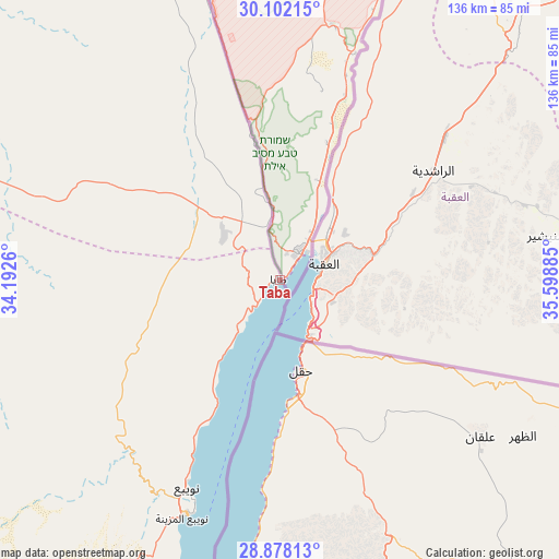
Taba GPS coordinates[2]
29° 29' 31.164" North, 34° 53' 44.592" East
| Map corner | latitude | longitude |
|---|---|---|
| Upper-left | 30.10215°, | 34.1926° |
| Center: | 29.49199°, | 34.89572° |
| Lower-right: | 28.87813°, | 35.59885° |
| Map W x H: | 136.1×136.1 km | = 84.6×84.6mi |
| max Lat: | 31.5084° ⇑58.7% North |
| Taba: | 29.49199° |
| min Lat: | ⇓41.3% South 22.3457° |
| min Long | Taba | max Long |
| 25.51965° | 34.89572° | 34.89572° |
| W 100%⇐ | ⇒0% E |
Elevation
Elevation of Taba is 12 m = 39 ft, and this is 31.5 m = 103 ft below average elevation for this country.
| Max E: |
1565 m = 5135 ft | 73.9% |
| Avg. | 43.5 m = 143 ft | |
| Taba | 12 m = 39 ft | |
Min E: |
-15 m = -49 ft | 26.1% |
See also: Egypt elevation on elevation.city.
Geographical zone
Taba is located in North temperate zone (between Tropic of Cancer and the Arctic Circle). Distance of this Northern Tropic circle is 673.3 km =418.4 mi to South.| Distance of | km | miles | from Taba |
|---|---|---|---|
| North Pole | 6727.9 | 4180.5 | to North |
| Arctic Circle | 4122 | 2561.3 | to North |
| Tropic Cancer | 673.3 | 418.4 | to South |
| Equator | 3279.2 | 2037.6 | to South |


Nearby cities:
15 places around Taba: (largest is in red/bold)
• Ain Sukhna
249.8 km =155.2 mi,  272°
272°
• Arish
210.5 km =130.8 mi,  329°
329°
• Ash Shaykh Zuwayd
206 km =128 mi,  338°
338°
• Bi’r al ‘Abd
248.2 km =154.2 mi,  313°
313°
• Dahab
118.9 km =73.9 mi,  199°
199°
• El Gouna
261.9 km =162.7 mi,  207°
207°
• El-Tor
186.3 km =115.8 mi,  221°
221°
• Hurghada
270.1 km =167.8 mi, 203°
• Ismailia
281.1 km =174.7 mi,  296°
296°
• Nuwaybi‘a
54.4 km =33.8 mi, 204°
• Rafaḩ
208.8 km =129.7 mi, 342°
• Ras Gharib
217.2 km =135 mi,  234°
234°
• Saint Catherine
138.4 km =86 mi, 221°
• Sharm el-Sheikh
183.7 km =114.1 mi, 197°
• Suez
235 km =146 mi,  283°
283°
Sources, notices
• [Note1] Compared only with cities in Egypt existing in our database
• [Src1] Map data: © OpenStreetMap contributors (CC-BY-SA)
• [Src2] Other city data from geonames.org with taken over terms of usage.
• [Src3] Geographical zone / Annual Mean Temperature by Robert A. Rohde @ Wikipedia
