Sharm el-Sheikh geodata
Sharm el-Sheikh (South Sinai) is a populated place; located in Egypt in Africa/Cairo (GMT+2) time zone. With population of 12,000 people, there are 123 cities with bigger population in this country. Compared to other cities in Egypt, 74.6% of cities are located further ↑North; 97.1% of cities are located further ←West and 81.2% of cities have higher elevation than Sharm el-Sheikh. Note1


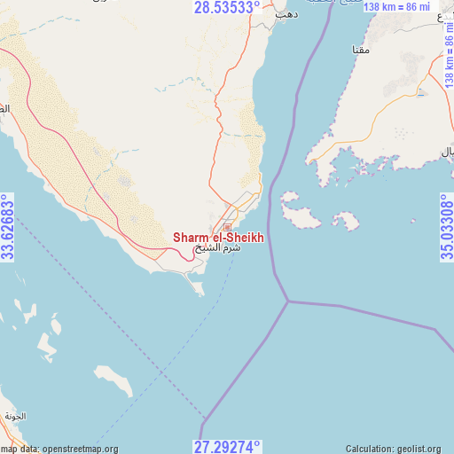
Sharm el-Sheikh GPS coordinates[2]
27° 54' 56.952" North, 34° 19' 47.82" East
| Map corner | latitude | longitude |
|---|---|---|
| Upper-left | 28.53533°, | 33.62683° |
| Center: | 27.91582°, | 34.32995° |
| Lower-right: | 27.29274°, | 35.03308° |
| Map W x H: | 138.2×138.2 km | = 85.9×85.9mi |
| max Lat: | 31.5084° ⇑74.6% North |
| Sharm el-Sheikh: | 27.91582° |
| min Lat: | ⇓25.4% South 22.3457° |
| min Long | Sharm el-Sheikh | max Long |
| 25.51965° | 34.32995° | 34.89572° |
| W 97.1%⇐ | ⇒2.9% E |
Elevation
Elevation of Sharm el-Sheikh is 11 m = 36 ft, and this is 32.5 m = 107 ft below average elevation for this country.
| Max E: |
1565 m = 5135 ft | 81.2% |
| Avg. | 43.5 m = 143 ft | |
| Sharm el-Sheikh | 11 m = 36 ft | |
Min E: |
-15 m = -49 ft | 18.8% |
See also: Egypt elevation on elevation.city.
Geographical zone
Sharm el-Sheikh is located in North temperate zone (between Tropic of Cancer and the Arctic Circle). Distance of this Northern Tropic circle is 498 km =309.4 mi to South.| Distance of | km | miles | from Sharm el-Sheikh |
|---|---|---|---|
| North Pole | 6903.1 | 4289.4 | to North |
| Arctic Circle | 4297.2 | 2670.2 | to North |
| Tropic Cancer | 498 | 309.4 | to South |
| Equator | 3103.9 | 1928.7 | to South |


Nearby cities:
15 places around Sharm el-Sheikh: (largest is in red/bold)
• Ain Sukhna
271.3 km =168.6 mi,  313°
313°
• Al Quşayr
201.5 km =125.2 mi,  181°
181°
• Dahab
65 km =40.4 mi,  14°
14°
• Dishnā
270.9 km =168.3 mi,  222°
222°
• El Gouna
86.5 km =53.7 mi,  227°
227°
• El-Tor
78.3 km =48.7 mi,  297°
297°
• Hurghada
89.2 km =55.4 mi,  214°
214°
• Kousa
271.3 km =168.6 mi, 214°
• Makadi Bay
111.2 km =69.1 mi,  202°
202°
• Nuwaybi‘a
129.9 km =80.7 mi, 14°
• Qinā
251.3 km =156.2 mi, 219°
• Ras Gharib
132.2 km =82.1 mi,  291°
291°
• Safaga
135.4 km =84.1 mi, 196°
• Saint Catherine
80.9 km =50.3 mi,  332°
332°
• Taba
183.7 km =114.1 mi,  17°
17°
In other languages:
- In Spanish: Sharm el-Sheij
- In France: Charm el-Cheikh
- In German: Sharm el Sheikh
- In Russian: Шарм-эль-Шейх
- In Chinese: 沙姆沙伊赫
Sources, notices
• [Note1] Compared only with cities in Egypt existing in our database
• [Src1] Map data: © OpenStreetMap contributors (CC-BY-SA)
• [Src2] Other city data from geonames.org with taken over terms of usage.
• [Src3] Geographical zone / Annual Mean Temperature by Robert A. Rohde @ Wikipedia
