Makadi Bay geodata
Makadi Bay (Red Sea) is a populated place; located in Egypt in Africa/Cairo (GMT+2) time zone. With population of 4,000 people, there are 132 cities with bigger population in this country. Compared to other cities in Egypt, 84.1% of cities are located further ↑North; 92.8% of cities are located further ←West and 95.7% of cities have higher elevation than Makadi Bay. Note1


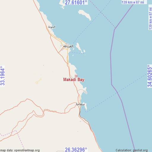
Makadi Bay GPS coordinates[2]
26° 59' 28.428" North, 33° 53' 58.272" East
| Map corner | latitude | longitude |
|---|---|---|
| Upper-left | 27.61601°, | 33.1964° |
| Center: | 26.99123°, | 33.89952° |
| Lower-right: | 26.36296°, | 34.60265° |
| Map W x H: | 139.3×139.3 km | = 86.6×86.6mi |
| max Lat: | 31.5084° ⇑84.1% North |
| Makadi Bay: | 26.99123° |
| min Lat: | ⇓15.9% South 22.3457° |
| min Long | Makadi Bay | max Long |
| 25.51965° | 33.89952° | 34.89572° |
| W 92.8%⇐ | ⇒7.2% E |
Elevation
Elevation of Makadi Bay is 5 m = 16 ft, and this is 38.5 m = 126 ft below average elevation for this country.
| Max E: |
1565 m = 5135 ft | 95.7% |
| Avg. | 43.5 m = 143 ft | |
| Makadi Bay | 5 m = 16 ft | |
Min E: |
-15 m = -49 ft | 4.3% |
See also: Egypt elevation on elevation.city.
Geographical zone
Makadi Bay is located in North temperate zone (between Tropic of Cancer and the Arctic Circle). Distance of this Northern Tropic circle is 395.2 km =245.6 mi to South.| Distance of | km | miles | from Makadi Bay |
|---|---|---|---|
| North Pole | 7005.9 | 4353.3 | to North |
| Arctic Circle | 4400 | 2734 | to North |
| Tropic Cancer | 395.2 | 245.6 | to South |
| Equator | 3001.1 | 1864.8 | to South |


Nearby cities:
15 places around Makadi Bay: (largest is in red/bold)
• Al Quşayr
105.6 km =65.6 mi,  159°
159°
• Dahab
175.8 km =109.2 mi,  19°
19°
• Dishnā
171.3 km =106.4 mi,  235°
235°
• El Gouna
49.9 km =31 mi,  333°
333°
• El-Tor
141.7 km =88 mi,  348°
348°
• Farshūţ
201.7 km =125.3 mi, 238°
• Hurghada
30.8 km =19.1 mi,  343°
343°
• Kousa
164.7 km =102.3 mi,  223°
223°
• Luxor
190.6 km =118.4 mi, 221°
• Naja' Ḥammādī
195.4 km =121.4 mi, 237°
• Qinā
148.5 km =92.3 mi,  231°
231°
• Ras Gharib
172.2 km =107 mi, 331°
• Safaga
27.2 km =16.9 mi,  171°
171°
• Saint Catherine
174.7 km =108.6 mi,  1°
1°
• Sharm el-Sheikh
111.2 km =69.1 mi, 22°
Sources, notices
• [Note1] Compared only with cities in Egypt existing in our database
• [Src1] Map data: © OpenStreetMap contributors (CC-BY-SA)
• [Src2] Other city data from geonames.org with taken over terms of usage.
• [Src3] Geographical zone / Annual Mean Temperature by Robert A. Rohde @ Wikipedia
