El-Tor geodata
El-Tor (South Sinai) is a seat of a first-order administrative division; located in Egypt in Africa/Cairo (GMT+2) time zone. With population of 14,972 people, there are 122 cities with bigger population in this country. Compared to other cities in Egypt, 72.5% of cities are located further ↑North; 89.9% of cities are located further ←West and 65.2% of cities have higher elevation than El-Tor. Note1


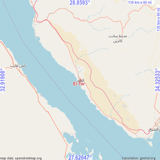
El-Tor GPS coordinates[2]
28° 14' 30.048" North, 33° 37' 19.92" East
| Map corner | latitude | longitude |
|---|---|---|
| Upper-left | 28.8593°, | 32.91908° |
| Center: | 28.24168°, | 33.6222° |
| Lower-right: | 27.62047°, | 34.32533° |
| Map W x H: | 137.7×137.7 km | = 85.6×85.6mi |
| max Lat: | 31.5084° ⇑72.5% North |
| El-Tor: | 28.24168° |
| min Lat: | ⇓27.5% South 22.3457° |
| min Long | El-Tor | max Long |
| 25.51965° | 33.6222° | 34.89572° |
| W 89.9%⇐ | ⇒10.1% E |
Elevation
Elevation of El-Tor is 14 m = 46 ft, and this is 29.5 m = 97 ft below average elevation for this country.
| Max E: |
1565 m = 5135 ft | 65.2% |
| Avg. | 43.5 m = 143 ft | |
| El-Tor | 14 m = 46 ft | |
Min E: |
-15 m = -49 ft | 34.8% |
See also: Egypt elevation on elevation.city.
Geographical zone
El-Tor is located in North temperate zone (between Tropic of Cancer and the Arctic Circle). Distance of this Northern Tropic circle is 534.3 km =332 mi to South.| Distance of | km | miles | from El-Tor |
|---|---|---|---|
| North Pole | 6866.9 | 4266.9 | to North |
| Arctic Circle | 4261 | 2647.7 | to North |
| Tropic Cancer | 534.3 | 332 | to South |
| Equator | 3140.2 | 1951.2 | to South |


Nearby cities:
15 places around El-Tor: (largest is in red/bold)
• Ain Sukhna
197.4 km =122.7 mi,  319°
319°
• Al Badārī
258 km =160.3 mi,  237°
237°
• Al Quşayr
246.3 km =153 mi,  164°
164°
• Dahab
89.5 km =55.6 mi,  72°
72°
• El Gouna
94.4 km =58.7 mi,  176°
176°
• Hurghada
111 km =69 mi,  170°
170°
• Makadi Bay
141.7 km =88 mi, 168°
• Nuwaybi‘a
135.4 km =84.1 mi,  48°
48°
• Qinā
247.4 km =153.7 mi,  200°
200°
• Ras Gharib
54.8 km =34.1 mi,  283°
283°
• Safaga
168.9 km =104.9 mi, 169°
• Saint Catherine
47.9 km =29.8 mi,  41°
41°
• Sharm el-Sheikh
78.3 km =48.7 mi,  117°
117°
• Suez
220 km =136.7 mi,  331°
331°
• Taba
186.3 km =115.8 mi, 41°
Sources, notices
• [Note1] Compared only with cities in Egypt existing in our database
• [Src1] Map data: © OpenStreetMap contributors (CC-BY-SA)
• [Src2] Other city data from geonames.org with taken over terms of usage.
• [Src3] Geographical zone / Annual Mean Temperature by Robert A. Rohde @ Wikipedia
