Werota geodata
Werota (Amhara) is a populated place; located in Ethiopia in Africa/Addis_Ababa (GMT+3) time zone. With population of 26,813 people, there are 45 cities with bigger population in this country. Compared to other cities in Ethiopia, 88.8% of cities are located further ↓South; 72.9% of cities are located further →East and 57.9% of cities have higher elevation than Werota. Note1


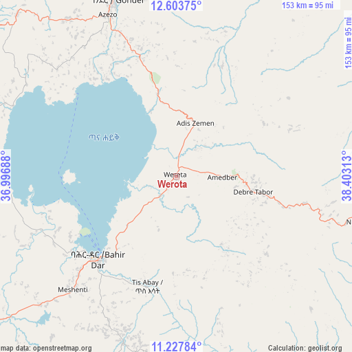
Werota GPS coordinates[2]
11° 55' 0.012" North, 37° 42' 0" East
| Map corner | latitude | longitude |
|---|---|---|
| Upper-left | 12.60375°, | 36.99688° |
| Center: | 11.91667°, | 37.7° |
| Lower-right: | 11.22784°, | 38.40313° |
| Map W x H: | 153×153 km | = 95.1×95.1mi |
| max Lat: | 14.277° ⇑11.2% North |
| Werota: | 11.91667° |
| min Lat: | ⇓88.8% South 4.05° |
| min Long | Werota | max Long |
| 34.53333° | 37.7° | 42.8° |
| W 27.1%⇐ | ⇒72.9% E |
Elevation
Elevation of Werota is 1810 m = 5938 ft, and this is 85.6 m = 281 ft below average elevation for this country.
| Max E: |
2854 m = 9364 ft | 57.9% |
| Avg. | 1895.6 m = 6219 ft | |
| Werota | 1810 m = 5938 ft | |
Min E: |
367 m = 1204 ft | 42.1% |
See also: Ethiopia elevation on elevation.city.
Geographical zone
Werota is located in North Torrid zone (between Equator and Tropic of Cancer). Distance of this Northern Tropic circle is 1280.9 km =795.9 mi to North.| Distance of | km | miles | from Werota |
|---|---|---|---|
| North Pole | 8682.1 | 5394.8 | to North |
| Arctic Circle | 6076.2 | 3775.6 | to North |
| Tropic Cancer | 1280.9 | 795.9 | to North |
| Equator | 1325 | 823.3 | to South |


Nearby cities:
15 places around Werota: (largest is in red/bold)
• Addiet Canna
76 km =47.2 mi,  198°
198°
• Bahir Dar
49.2 km =30.6 mi,  223°
223°
• Bichena
172 km =106.9 mi,  161°
161°
• Burē
151.9 km =94.4 mi,  207°
207°
• Dabat
118.9 km =73.9 mi,  3°
3°
• Debark’
139.5 km =86.7 mi,  8°
8°
• Debre Mark’os
174.2 km =108.2 mi,  178°
178°
• Debre Tabor
35.2 km =21.9 mi,  102°
102°
• Debre Werk’
148 km =92 mi, 159°
• Dejen
200.2 km =124.4 mi,  166°
166°
• Finote Selam
143.3 km =89 mi, 199°
• Gondar
80.1 km =49.8 mi,  341°
341°
• Korem
208.6 km =129.6 mi,  71°
71°
• Lalībela
147.1 km =91.4 mi,  84°
84°
• Ādīs Zemen
24 km =14.9 mi,  22°
22°
Sources, notices
• [Note1] Compared only with cities in Ethiopia existing in our database
• [Src1] Map data: © OpenStreetMap contributors (CC-BY-SA)
• [Src2] Other city data from geonames.org with taken over terms of usage.
• [Src3] Geographical zone / Annual Mean Temperature by Robert A. Rohde @ Wikipedia
