Ādīs Zemen geodata
Ādīs Zemen (Amhara) is a populated place; located in Ethiopia in Africa/Addis_Ababa (GMT+3) time zone. With population of 22,522 people, there are 60 cities with bigger population in this country. Compared to other cities in Ethiopia, 91.6% of cities are located further ↓South; 68.2% of cities are located further →East and 58.9% of cities have lower elevation than Ādīs Zemen. Note1


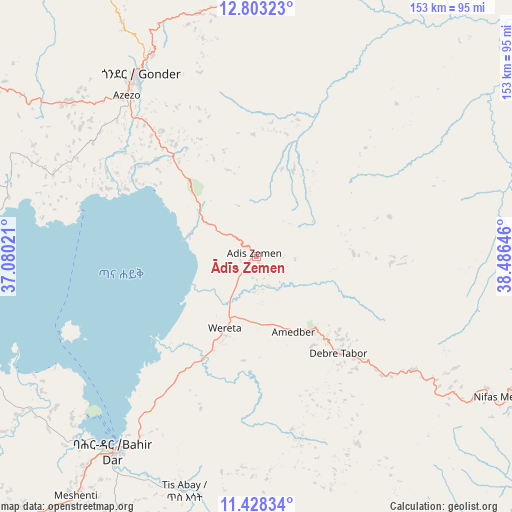
Ādīs Zemen GPS coordinates[2]
12° 7' 0.012" North, 37° 46' 59.988" East
| Map corner | latitude | longitude |
|---|---|---|
| Upper-left | 12.80323°, | 37.08021° |
| Center: | 12.11667°, | 37.78333° |
| Lower-right: | 11.42834°, | 38.48646° |
| Map W x H: | 152.9×152.9 km | = 95×95mi |
| max Lat: | 14.277° ⇑8.4% North |
| Ādīs Zemen: | 12.11667° |
| min Lat: | ⇓91.6% South 4.05° |
| min Long | Ādīs Zemen | max Long |
| 34.53333° | 37.78333° | 42.8° |
| W 31.8%⇐ | ⇒68.2% E |
Elevation
Elevation of Ādīs Zemen is 2023 m = 6637 ft, and this is 127.4 m = 418 ft above average elevation for this country.
| Max E: |
2854 m = 9364 ft | 41.1% |
| Ādīs Zemen | 2023 m 6637 ft | |
| Avg. | 1895.6 m = 6219 ft | |
Min E: |
367 m = 1204 ft | 58.9% |
See also: Ethiopia elevation on elevation.city.
Geographical zone
Ādīs Zemen is located in North Torrid zone (between Equator and Tropic of Cancer). Distance of this Northern Tropic circle is 1258.7 km =782.1 mi to North.| Distance of | km | miles | from Ādīs Zemen |
|---|---|---|---|
| North Pole | 8659.8 | 5380.9 | to North |
| Arctic Circle | 6053.9 | 3761.7 | to North |
| Tropic Cancer | 1258.7 | 782.1 | to North |
| Equator | 1347.2 | 837.1 | to South |


Nearby cities:
15 places around Ādīs Zemen: (largest is in red/bold)
• Addiet Canna
100 km =62.1 mi,  199°
199°
• Bahir Dar
72.2 km =44.9 mi,  216°
216°
• Bichena
190.8 km =118.6 mi,  166°
166°
• Burē
175.8 km =109.2 mi,  206°
206°
• Dabat
96.5 km =60 mi,  358°
358°
• Debark’
116.2 km =72.2 mi,  6°
6°
• Debre Mark’os
196.5 km =122.1 mi,  181°
181°
• Debre Tabor
39 km =24.2 mi,  139°
139°
• Debre Werk’
166.6 km =103.5 mi, 165°
• Finote Selam
167.3 km =104 mi, 199°
• Gondar
63.8 km =39.6 mi,  327°
327°
• Korem
193.9 km =120.5 mi,  77°
77°
• Lalībela
137.8 km =85.6 mi,  93°
93°
• Robīt
201.5 km =125.2 mi, 93°
• Werota
24 km =14.9 mi, 202°
Sources, notices
• [Note1] Compared only with cities in Ethiopia existing in our database
• [Src1] Map data: © OpenStreetMap contributors (CC-BY-SA)
• [Src2] Other city data from geonames.org with taken over terms of usage.
• [Src3] Geographical zone / Annual Mean Temperature by Robert A. Rohde @ Wikipedia
