Gondar geodata
Gondar (Amhara) is a populated place; located in Ethiopia in Africa/Addis_Ababa (GMT+3) time zone. With population of 153,914 people, there are 5 cities with bigger population in this country. Compared to other cities in Ethiopia, 93.5% of cities are located further ↓South; 76.6% of cities are located further →East and 70.1% of cities have lower elevation than Gondar. Note1


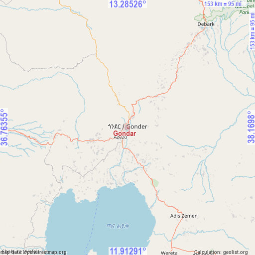
Gondar GPS coordinates[2]
12° 36' 0" North, 37° 28' 0.012" East
| Map corner | latitude | longitude |
|---|---|---|
| Upper-left | 13.28526°, | 36.76355° |
| Center: | 12.6°, | 37.46667° |
| Lower-right: | 11.91291°, | 38.1698° |
| Map W x H: | 152.6×152.6 km | = 94.8×94.8mi |
| max Lat: | 14.277° ⇑6.5% North |
| Gondar: | 12.6° |
| min Lat: | ⇓93.5% South 4.05° |
| min Long | Gondar | max Long |
| 34.53333° | 37.46667° | 42.8° |
| W 23.4%⇐ | ⇒76.6% E |
Elevation
Elevation of Gondar is 2201 m = 7221 ft, and this is 305.4 m = 1002 ft above average elevation for this country.
| Max E: |
2854 m = 9364 ft | 29.9% |
| Gondar | 2201 m 7221 ft | |
| Avg. | 1895.6 m = 6219 ft | |
Min E: |
367 m = 1204 ft | 70.1% |
See also: Gondar elevation on elevation.city.
Geographical zone
Gondar is located in North Torrid zone (between Equator and Tropic of Cancer). Distance of this Northern Tropic circle is 1204.9 km =748.7 mi to North.| Distance of | km | miles | from Gondar |
|---|---|---|---|
| North Pole | 8606.1 | 5347.6 | to North |
| Arctic Circle | 6000.2 | 3728.4 | to North |
| Tropic Cancer | 1204.9 | 748.7 | to North |
| Equator | 1401 | 870.5 | to South |


Nearby cities:
15 places around Gondar: (largest is in red/bold)
• Addiet Canna
148.3 km =92.1 mi,  179°
179°
• Axum
217 km =134.8 mi,  38°
38°
• Bahir Dar
112.2 km =69.7 mi, 184°
• Burē
215.7 km =134 mi,  191°
191°
• Dabat
53.6 km =33.3 mi, 37°
• Debark’
77.5 km =48.2 mi, 37°
• Debre Tabor
102.6 km =63.8 mi,  144°
144°
• Debre Werk’
228.1 km =141.7 mi,  160°
160°
• Finote Selam
212.4 km =132 mi, 185°
• Inda Silasē
189 km =117.4 mi,  27°
27°
• Korem
223.4 km =138.8 mi,  92°
92°
• Lalībela
183 km =113.7 mi,  110°
110°
• Maych’ew
226.1 km =140.5 mi,  84°
84°
• Werota
80.1 km =49.8 mi, 161°
• Ādīs Zemen
63.8 km =39.6 mi,  147°
147°
Sources, notices
• [Note1] Compared only with cities in Ethiopia existing in our database
• [Src1] Map data: © OpenStreetMap contributors (CC-BY-SA)
• [Src2] Other city data from geonames.org with taken over terms of usage.
• [Src3] Geographical zone / Annual Mean Temperature by Robert A. Rohde @ Wikipedia
