Lalībela geodata
Lalībela (Amhara) is a populated place; located in Ethiopia in Africa/Addis_Ababa (GMT+3) time zone. With population of 11,152 people, there are 89 cities with bigger population in this country. Compared to other cities in Ethiopia, 90.7% of cities are located further ↓South; 66.4% of cities are located further ←West and 82.2% of cities have lower elevation than Lalībela. Note1


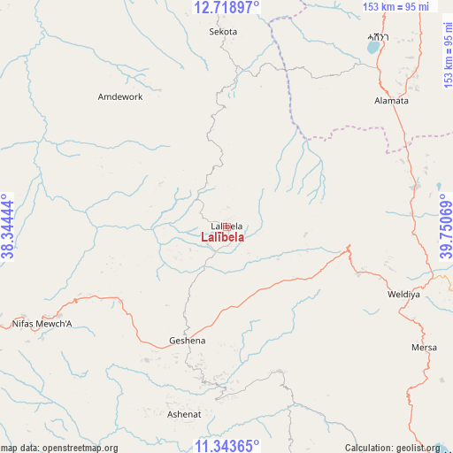
Lalībela GPS coordinates[2]
12° 1' 55.884" North, 39° 2' 51.216" East
| Map corner | latitude | longitude |
|---|---|---|
| Upper-left | 12.71897°, | 38.34444° |
| Center: | 12.03219°, | 39.04756° |
| Lower-right: | 11.34365°, | 39.75069° |
| Map W x H: | 152.9×152.9 km | = 95×95mi |
| max Lat: | 14.277° ⇑9.3% North |
| Lalībela: | 12.03219° |
| min Lat: | ⇓90.7% South 4.05° |
| min Long | Lalībela | max Long |
| 34.53333° | 39.04756° | 42.8° |
| W 66.4%⇐ | ⇒33.6% E |
Elevation
Elevation of Lalībela is 2481 m = 8140 ft, and this is 585.4 m = 1921 ft above average elevation for this country.
| Max E: |
2854 m = 9364 ft | 17.8% |
| Lalībela | 2481 m 8140 ft | |
| Avg. | 1895.6 m = 6219 ft | |
Min E: |
367 m = 1204 ft | 82.2% |
See also: Ethiopia elevation on elevation.city.
Geographical zone
Lalībela is located in North Torrid zone (between Equator and Tropic of Cancer). Distance of this Northern Tropic circle is 1268.1 km =788 mi to North.| Distance of | km | miles | from Lalībela |
|---|---|---|---|
| North Pole | 8669.2 | 5386.8 | to North |
| Arctic Circle | 6063.3 | 3767.6 | to North |
| Tropic Cancer | 1268.1 | 788 | to North |
| Equator | 1337.9 | 831.3 | to South |


Nearby cities:
15 places around Lalībela: (largest is in red/bold)
• Batī
141 km =87.6 mi,  131°
131°
• Dabat
174.9 km =108.7 mi,  307°
307°
• Debark’
176.6 km =109.7 mi,  315°
315°
• Debre Tabor
114 km =70.8 mi,  259°
259°
• Debre Werk’
179.7 km =111.7 mi,  212°
212°
• Desē
118.6 km =73.7 mi,  147°
147°
• Kemisē
171.6 km =106.6 mi, 148°
• Kombolcha
130.1 km =80.8 mi,  144°
144°
• Korem
73.8 km =45.9 mi,  44°
44°
• Maych’ew
99.7 km =62 mi,  32°
32°
• Mek'ele
169.3 km =105.2 mi,  15°
15°
• Robīt
63.7 km =39.6 mi,  91°
91°
• Were Īlu
165.9 km =103.1 mi,  165°
165°
• Werota
147.1 km =91.4 mi, 264°
• Ādīs Zemen
137.8 km =85.6 mi,  273°
273°
In other languages:
- In France: Lalibela
- In German: Lalibela
- In Italian: Lalibela
- In Russian: Лалибэла
- In Chinese: 拉利貝拉
Sources, notices
• [Note1] Compared only with cities in Ethiopia existing in our database
• [Src1] Map data: © OpenStreetMap contributors (CC-BY-SA)
• [Src2] Other city data from geonames.org with taken over terms of usage.
• [Src3] Geographical zone / Annual Mean Temperature by Robert A. Rohde @ Wikipedia
