Dabat geodata
Dabat (Amhara) is a populated place; located in Ethiopia in Africa/Addis_Ababa (GMT+3) time zone. With population of 11,544 people, there are 85 cities with bigger population in this country. Compared to other cities in Ethiopia, 95.3% of cities are located further ↓South; 69.2% of cities are located further →East and 91.6% of cities have lower elevation than Dabat. Note1


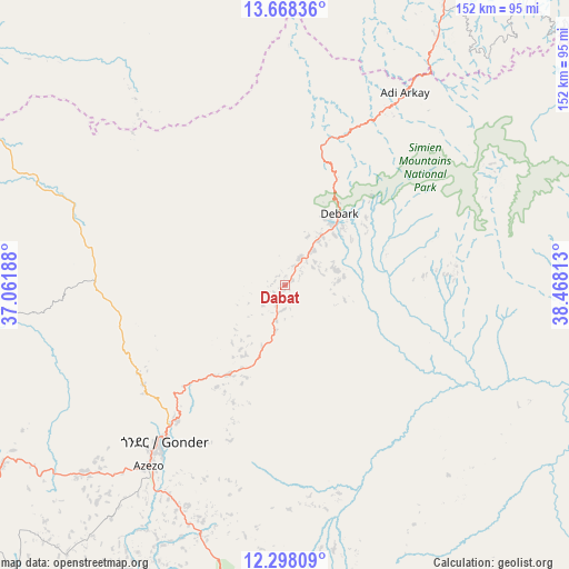
Dabat GPS coordinates[2]
12° 59' 3.012" North, 37° 45' 54" East
| Map corner | latitude | longitude |
|---|---|---|
| Upper-left | 13.66836°, | 37.06188° |
| Center: | 12.98417°, | 37.765° |
| Lower-right: | 12.29809°, | 38.46813° |
| Map W x H: | 152.4×152.4 km | = 94.7×94.7mi |
| max Lat: | 14.277° ⇑4.7% North |
| Dabat: | 12.98417° |
| min Lat: | ⇓95.3% South 4.05° |
| min Long | Dabat | max Long |
| 34.53333° | 37.765° | 42.8° |
| W 30.8%⇐ | ⇒69.2% E |
Elevation
Elevation of Dabat is 2602 m = 8537 ft, and this is 706.4 m = 2318 ft above average elevation for this country.
| Max E: |
2854 m = 9364 ft | 8.4% |
| Dabat | 2602 m 8537 ft | |
| Avg. | 1895.6 m = 6219 ft | |
Min E: |
367 m = 1204 ft | 91.6% |
See also: Ethiopia elevation on elevation.city.
Geographical zone
Dabat is located in North Torrid zone (between Equator and Tropic of Cancer). Distance of this Northern Tropic circle is 1162.2 km =722.2 mi to North.| Distance of | km | miles | from Dabat |
|---|---|---|---|
| North Pole | 8563.4 | 5321 | to North |
| Arctic Circle | 5957.5 | 3701.8 | to North |
| Tropic Cancer | 1162.2 | 722.2 | to North |
| Equator | 1443.7 | 897.1 | to South |


Nearby cities:
15 places around Dabat: (largest is in red/bold)
• Addiet Canna
193.4 km =120.2 mi,  189°
189°
• Axum
163.4 km =101.5 mi,  39°
39°
• Bahir Dar
159.9 km =99.4 mi, 194°
• Debark’
23.9 km =14.9 mi, 37°
• Debre Tabor
129 km =80.2 mi,  167°
167°
• Gondar
53.6 km =33.3 mi,  217°
217°
• Inda Silasē
136.4 km =84.8 mi,  24°
24°
• Korem
197.9 km =123 mi,  105°
105°
• Lalībela
174.9 km =108.7 mi,  127°
127°
• Maych’ew
193.9 km =120.5 mi,  96°
96°
• Mek'ele
193.7 km =120.4 mi,  72°
72°
• Robīt
229.6 km =142.7 mi,  117°
117°
• Werota
118.9 km =73.9 mi,  183°
183°
• Ādīgrat
233 km =144.8 mi,  51°
51°
• Ādīs Zemen
96.5 km =60 mi, 178°
Sources, notices
• [Note1] Compared only with cities in Ethiopia existing in our database
• [Src1] Map data: © OpenStreetMap contributors (CC-BY-SA)
• [Src2] Other city data from geonames.org with taken over terms of usage.
• [Src3] Geographical zone / Annual Mean Temperature by Robert A. Rohde @ Wikipedia
