Debark’ geodata
Debark’ (Amhara) is a populated place; located in Ethiopia in Africa/Addis_Ababa (GMT+3) time zone. With population of 24,700 people, there are 51 cities with bigger population in this country. Compared to other cities in Ethiopia, 96.3% of cities are located further ↓South; 64.5% of cities are located further →East and 100% of cities have lower elevation than Debark’. Note1


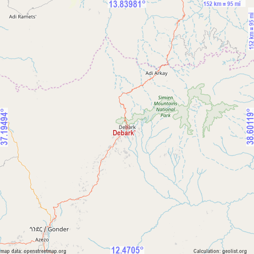
Debark’ GPS coordinates[2]
13° 9' 21.996" North, 37° 53' 53.016" East
| Map corner | latitude | longitude |
|---|---|---|
| Upper-left | 13.83981°, | 37.19494° |
| Center: | 13.15611°, | 37.89806° |
| Lower-right: | 12.4705°, | 38.60119° |
| Map W x H: | 152.3×152.3 km | = 94.6×94.6mi |
| max Lat: | 14.277° ⇑3.7% North |
| Debark’: | 13.15611° |
| min Lat: | ⇓96.3% South 4.05° |
| min Long | Debark’ | max Long |
| 34.53333° | 37.89806° | 42.8° |
| W 35.5%⇐ | ⇒64.5% E |
Elevation
Elevation of Debark’ is 2854 m = 9364 ft, and this is 958.4 m = 3144 ft above average elevation for this country.
| Max E: |
2854 m = 9364 ft | 0% |
| Debark’ | 2854 m 9364 ft | |
| Avg. | 1895.6 m = 6219 ft | |
Min E: |
367 m = 1204 ft | 100% |
See also: Ethiopia elevation on elevation.city.
Geographical zone
Debark’ is located in North Torrid zone (between Equator and Tropic of Cancer). Distance of this Northern Tropic circle is 1143.1 km =710.3 mi to North.| Distance of | km | miles | from Debark’ |
|---|---|---|---|
| North Pole | 8544.2 | 5309.1 | to North |
| Arctic Circle | 5938.4 | 3689.9 | to North |
| Tropic Cancer | 1143.1 | 710.3 | to North |
| Equator | 1462.8 | 908.9 | to South |


Nearby cities:
15 places around Debark’: (largest is in red/bold)
• Addiet Canna
214.9 km =133.5 mi,  192°
192°
• Axum
139.5 km =86.7 mi,  39°
39°
• Bahir Dar
182.3 km =113.3 mi,  197°
197°
• Dabat
23.9 km =14.9 mi,  217°
217°
• Debre Tabor
145.8 km =90.6 mi,  174°
174°
• Gondar
77.5 km =48.2 mi, 217°
• Inda Silasē
113.2 km =70.3 mi,  21°
21°
• Korem
190.4 km =118.3 mi,  112°
112°
• Lalībela
176.6 km =109.7 mi,  135°
135°
• Maych’ew
182.8 km =113.6 mi,  102°
102°
• Mek'ele
174.8 km =108.6 mi,  77°
77°
• Robīt
227 km =141.1 mi,  123°
123°
• Werota
139.5 km =86.7 mi, 188°
• Ādīgrat
209.9 km =130.4 mi,  53°
53°
• Ādīs Zemen
116.2 km =72.2 mi, 186°
Sources, notices
• [Note1] Compared only with cities in Ethiopia existing in our database
• [Src1] Map data: © OpenStreetMap contributors (CC-BY-SA)
• [Src2] Other city data from geonames.org with taken over terms of usage.
• [Src3] Geographical zone / Annual Mean Temperature by Robert A. Rohde @ Wikipedia
