Ginir geodata
Ginir (Oromiya) is a populated place; located in Ethiopia in Africa/Addis_Ababa (GMT+3) time zone. With population of 16,757 people, there are 74 cities with bigger population in this country. Compared to other cities in Ethiopia, 74.8% of cities are located further ↑North; 90.7% of cities are located further ←West and 54.2% of cities have lower elevation than Ginir. Note1


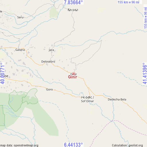
Ginir GPS coordinates[2]
7° 8' 22.272" North, 40° 42' 38.988" East
| Map corner | latitude | longitude |
|---|---|---|
| Upper-left | 7.83664°, | 40.00771° |
| Center: | 7.13952°, | 40.71083° |
| Lower-right: | 6.44133°, | 41.41396° |
| Map W x H: | 155.1×155.1 km | = 96.4×96.4mi |
| max Lat: | 14.277° ⇑74.8% North |
| Ginir: | 7.13952° |
| min Lat: | ⇓25.2% South 4.05° |
| min Long | Ginir | max Long |
| 34.53333° | 40.71083° | 42.8° |
| W 90.7%⇐ | ⇒9.3% E |
Elevation
Elevation of Ginir is 1945 m = 6381 ft, and this is 49.4 m = 162 ft above average elevation for this country.
| Max E: |
2854 m = 9364 ft | 45.8% |
| Ginir | 1945 m 6381 ft | |
| Avg. | 1895.6 m = 6219 ft | |
Min E: |
367 m = 1204 ft | 54.2% |
See also: Ethiopia elevation on elevation.city.
Geographical zone
Ginir is located in North Torrid zone (between Equator and Tropic of Cancer). Distance of Equator is 793.8 km =493.2 mi to South.| Distance of | km | miles | from Ginir |
|---|---|---|---|
| North Pole | 9213.2 | 5724.8 | to North |
| Arctic Circle | 6607.3 | 4105.6 | to North |
| Tropic Cancer | 1812.1 | 1126 | to North |
| Equator | 793.8 | 493.2 | to South |


Nearby cities:
15 places around Ginir: (largest is in red/bold)
• Bedēsa
195.9 km =121.7 mi,  2°
2°
• Dodola
169.4 km =105.3 mi,  264°
264°
• Gelemso
187.7 km =116.6 mi,  353°
353°
• Goba
81.4 km =50.6 mi, 260°
• Huruta
187.4 km =116.4 mi,  306°
306°
• Hīrna
234.9 km =146 mi,  10°
10°
• Kofelē
212.8 km =132.2 mi,  267°
267°
• Metahāra
214.4 km =133.2 mi,  335°
335°
• Nazrēt
223.4 km =138.8 mi, 314°
• Shashemenē
233 km =144.8 mi, 271°
• Sirre
188.2 km =116.9 mi, 314°
• Wenjī
214.4 km =133.2 mi, 312°
• Āsasa
166.8 km =103.6 mi, 268°
• Āsbe Teferī
217.1 km =134.9 mi, 4°
• Āwash
213.6 km =132.7 mi, 343°
Sources, notices
• [Note1] Compared only with cities in Ethiopia existing in our database
• [Src1] Map data: © OpenStreetMap contributors (CC-BY-SA)
• [Src2] Other city data from geonames.org with taken over terms of usage.
• [Src3] Geographical zone / Annual Mean Temperature by Robert A. Rohde @ Wikipedia
