Kemisē geodata
Kemisē (Amhara) is a populated place; located in Ethiopia in Africa/Addis_Ababa (GMT+3) time zone. With population of 23,861 people, there are 53 cities with bigger population in this country. Compared to other cities in Ethiopia, 79.4% of cities are located further ↓South; 83.2% of cities are located further ←West and 83.2% of cities have higher elevation than Kemisē. Note1


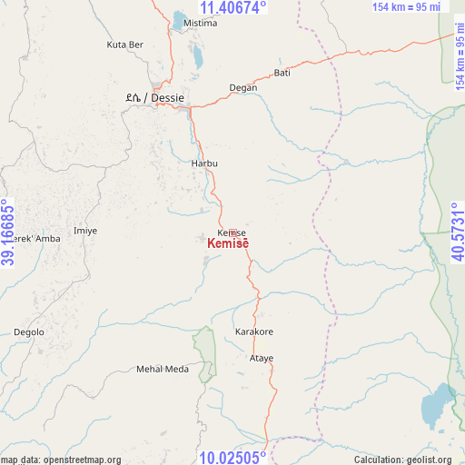
Kemisē GPS coordinates[2]
10° 43' 0.048" North, 39° 52' 11.892" East
| Map corner | latitude | longitude |
|---|---|---|
| Upper-left | 11.40674°, | 39.16685° |
| Center: | 10.71668°, | 39.86997° |
| Lower-right: | 10.02505°, | 40.5731° |
| Map W x H: | 153.6×153.6 km | = 95.4×95.4mi |
| max Lat: | 14.277° ⇑20.6% North |
| Kemisē: | 10.71668° |
| min Lat: | ⇓79.4% South 4.05° |
| min Long | Kemisē | max Long |
| 34.53333° | 39.86997° | 42.8° |
| W 83.2%⇐ | ⇒16.8% E |
Elevation
Elevation of Kemisē is 1438 m = 4718 ft, and this is 457.6 m = 1501 ft below average elevation for this country.
| Max E: |
2854 m = 9364 ft | 83.2% |
| Avg. | 1895.6 m = 6219 ft | |
| Kemisē | 1438 m = 4718 ft | |
Min E: |
367 m = 1204 ft | 16.8% |
See also: Ethiopia elevation on elevation.city.
Geographical zone
Kemisē is located in North Torrid zone (between Equator and Tropic of Cancer). Distance of Equator is 1191.6 km =740.4 mi to South.| Distance of | km | miles | from Kemisē |
|---|---|---|---|
| North Pole | 8815.5 | 5477.7 | to North |
| Arctic Circle | 6209.6 | 3858.5 | to North |
| Tropic Cancer | 1414.3 | 878.8 | to North |
| Equator | 1191.6 | 740.4 | to South |


Nearby cities:
15 places around Kemisē: (largest is in red/bold)
• Abomsa
82.5 km =51.3 mi,  171°
171°
• Batī
55.2 km =34.3 mi,  16°
16°
• Bichena
184.9 km =114.9 mi,  260°
260°
• Debre Birhan
121.1 km =75.2 mi,  197°
197°
• Debre Sīna
97.4 km =60.5 mi,  187°
187°
• Debre Werk’
186.2 km =115.7 mi,  268°
268°
• Desē
53 km =32.9 mi,  330°
330°
• Dubti
173.9 km =108.1 mi,  49°
49°
• Fichē
160.8 km =99.9 mi,  230°
230°
• Gewanē
104.7 km =65.1 mi,  125°
125°
• Kombolcha
42.9 km =26.7 mi,  341°
341°
• Lalībela
171.6 km =106.6 mi, 328°
• Robīt
146.8 km =91.2 mi,  349°
349°
• Semera
172.3 km =107.1 mi, 45°
• Were Īlu
49.3 km =30.6 mi,  253°
253°
Sources, notices
• [Note1] Compared only with cities in Ethiopia existing in our database
• [Src1] Map data: © OpenStreetMap contributors (CC-BY-SA)
• [Src2] Other city data from geonames.org with taken over terms of usage.
• [Src3] Geographical zone / Annual Mean Temperature by Robert A. Rohde @ Wikipedia
