Abomsa geodata
Abomsa (Amhara) is a populated place; located in Ethiopia in Africa/Addis_Ababa (GMT+3) time zone. With population of 15,258 people, there are 79 cities with bigger population in this country. Compared to other cities in Ethiopia, 70.1% of cities are located further ↓South; 85% of cities are located further ←West and 87.9% of cities have higher elevation than Abomsa. Note1


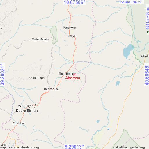
Abomsa GPS coordinates[2]
9° 58' 59.988" North, 39° 58' 59.988" East
| Map corner | latitude | longitude |
|---|---|---|
| Upper-left | 10.67506°, | 39.28021° |
| Center: | 9.98333°, | 39.98333° |
| Lower-right: | 9.29013°, | 40.68646° |
| Map W x H: | 154×154 km | = 95.7×95.7mi |
| max Lat: | 14.277° ⇑29.9% North |
| Abomsa: | 9.98333° |
| min Lat: | ⇓70.1% South 4.05° |
| min Long | Abomsa | max Long |
| 34.53333° | 39.98333° | 42.8° |
| W 85%⇐ | ⇒15% E |
Elevation
Elevation of Abomsa is 1300 m = 4265 ft, and this is 595.6 m = 1954 ft below average elevation for this country.
| Max E: |
2854 m = 9364 ft | 87.9% |
| Avg. | 1895.6 m = 6219 ft | |
| Abomsa | 1300 m = 4265 ft | |
Min E: |
367 m = 1204 ft | 12.1% |
See also: Ethiopia elevation on elevation.city.
Geographical zone
Abomsa is located in North Torrid zone (between Equator and Tropic of Cancer). Distance of Equator is 1110 km =689.7 mi to South.| Distance of | km | miles | from Abomsa |
|---|---|---|---|
| North Pole | 8897 | 5528.3 | to North |
| Arctic Circle | 6291.1 | 3909.1 | to North |
| Tropic Cancer | 1495.9 | 929.5 | to North |
| Equator | 1110 | 689.7 | to South |


Nearby cities:
15 places around Abomsa: (largest is in red/bold)
• Batī
134.4 km =83.5 mi,  1°
1°
• Bedēsa
149 km =92.6 mi,  143°
143°
• Debre Birhan
59.8 km =37.2 mi,  235°
235°
• Debre Sīna
28.7 km =17.8 mi, 238°
• Desē
133.5 km =83 mi,  343°
343°
• Fichē
138.4 km =86 mi,  261°
261°
• Gelemso
142.3 km =88.4 mi,  155°
155°
• Gewanē
75.4 km =46.9 mi,  74°
74°
• Kemisē
82.5 km =51.3 mi,  351°
351°
• Kombolcha
124.9 km =77.6 mi, 347°
• Metahāra
120.7 km =75 mi,  183°
183°
• Sendafa
140.1 km =87.1 mi,  228°
228°
• Were Īlu
90 km =55.9 mi,  318°
318°
• Āsbe Teferī
139.1 km =86.4 mi, 135°
• Āwash
113 km =70.2 mi,  169°
169°
Sources, notices
• [Note1] Compared only with cities in Ethiopia existing in our database
• [Src1] Map data: © OpenStreetMap contributors (CC-BY-SA)
• [Src2] Other city data from geonames.org with taken over terms of usage.
• [Src3] Geographical zone / Annual Mean Temperature by Robert A. Rohde @ Wikipedia
