Sinnamary geodata
Sinnamary (Guyane) is a seat of a third-order administrative division; located in French Guiana in America/Cayenne (GMT-3) time zone. With population of 3,180 people, there are 9 cities with bigger population in this country. Compared to other cities in French Guiana, 82.4% of cities are located further ↓South; 64.7% of cities are located further →East and 88.2% of cities have higher elevation than Sinnamary. Note1
Administrative division(s):
- Level 1: Guyane
- Level 2: Guyane
- Level 3: Arrondissement de Cayenne
- Level 4: Sinnamary


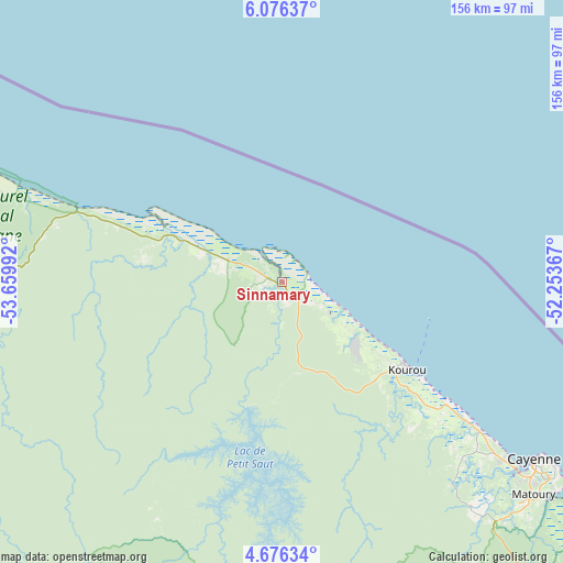
Sinnamary GPS coordinates[2]
5° 22' 36.336" North, 52° 57' 24.444" West
| Map corner | latitude | longitude |
|---|---|---|
| Upper-left | 6.07637°, | -53.65992° |
| Center: | 5.37676°, | -52.95679° |
| Lower-right: | 4.67634°, | -52.25367° |
| Map W x H: | 155.7×155.7 km | = 96.7×96.7mi |
| max Lat: | 5.66906° ⇑17.6% North |
| Sinnamary: | 5.37676° |
| min Lat: | ⇓82.4% South 3.16887° |
| min Long | Sinnamary | max Long |
| -54.38146° | -52.95679° | -51.80243° |
| W 35.3%⇐ | ⇒64.7% E |
Elevation
Elevation of Sinnamary is 6 m = 20 ft, and this is 17.9 m = 59 ft below average elevation for this country.
| Max E: |
106 m = 348 ft | 88.2% |
| Avg. | 23.9 m = 78 ft | |
| Sinnamary | 6 m = 20 ft | |
Min E: |
1 m = 3 ft | 11.8% |
See also: French Guiana elevation on elevation.city.
Geographical zone
Sinnamary is located in North Torrid zone (between Equator and Tropic of Cancer). Distance of Equator is 597.8 km =371.5 mi to South.| Distance of | km | miles | from Sinnamary |
|---|---|---|---|
| North Pole | 9409.2 | 5846.6 | to North |
| Arctic Circle | 6803.3 | 4227.4 | to North |
| Tropic Cancer | 2008.1 | 1247.8 | to North |
| Equator | 597.8 | 371.5 | to South |


Nearby cities:
15 places around Sinnamary: (largest is in red/bold)
• Apatou
155.5 km =96.6 mi,  260°
260°
• Cayenne
84.8 km =52.7 mi,  125°
125°
• Grand-Santi
199.9 km =124.2 mi,  232°
232°
• Iracoubo
29.8 km =18.5 mi,  292°
292°
• Kourou
42.1 km =26.2 mi,  124°
124°
• Macouria
82.6 km =51.3 mi, 128°
• Mana
96.6 km =60 mi, 289°
• Matoury
91.4 km =56.8 mi, 129°
• Roura
100.4 km =62.4 mi,  135°
135°
• Régina
149.5 km =92.9 mi, 142°
• Rémire
92.8 km =57.7 mi, 126°
• Rémire-Montjoly
92 km =57.2 mi, 123°
• Saint-Georges
209.2 km =130 mi, 142°
• Saint-Laurent-du-Maroni
119.5 km =74.3 mi,  276°
276°
• Tonate
67.3 km =41.8 mi, 127°
Sources, notices
• [Note1] Compared only with cities in French Guiana existing in our database
• [Src1] Map data: © OpenStreetMap contributors (CC-BY-SA)
• [Src2] Other city data from geonames.org with taken over terms of usage.
• [Src3] Geographical zone / Annual Mean Temperature by Robert A. Rohde @ Wikipedia
