Saint-Laurent-du-Maroni geodata
Saint-Laurent-du-Maroni (Guyane) is a seat of a second-order administrative division; located in French Guiana in America/Cayenne (GMT-3) time zone. With population of 24,287 people, there are 2 cities with bigger population in this country. Compared to other cities in French Guiana, 94.1% of cities are located further ↓South; 82.4% of cities are located further →East and 52.9% of cities have lower elevation than Saint-Laurent-du-Maroni. Note1
Administrative division(s):
- Level 1: Guyane
- Level 2: Guyane
- Level 3: Arrondissement de Saint-Laurent-du-Maroni
- Level 4: Saint-Laurent-du-Maroni
Current local time in Saint-Laurent-du-Maroni:
02:10 PM, MondayDifference from your time zone: hours


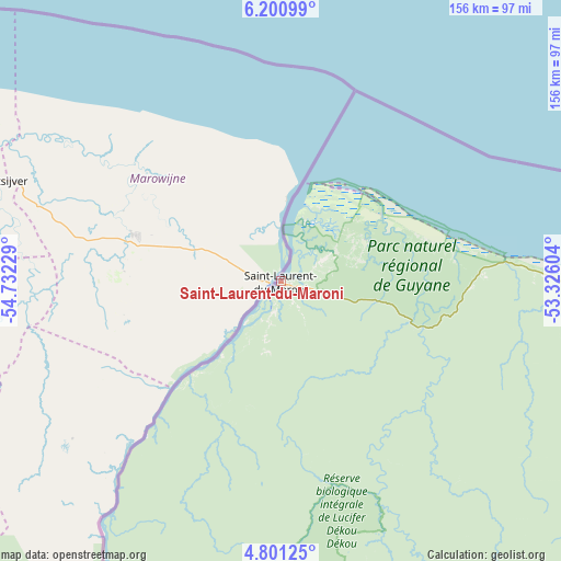
Saint-Laurent-du-Maroni GPS coordinates[2]
5° 30' 5.508" North, 54° 1' 44.976" West
| Map corner | latitude | longitude |
|---|---|---|
| Upper-left | 6.20099°, | -54.73229° |
| Center: | 5.50153°, | -54.02916° |
| Lower-right: | 4.80125°, | -53.32604° |
| Map W x H: | 155.6×155.6 km | = 96.7×96.7mi |
| max Lat: | 5.66906° ⇑5.9% North |
| Saint-Laurent-du-Maroni: | 5.50153° |
| min Lat: | ⇓94.1% South 3.16887° |
| min Long | Saint-Laurent-d | max Long |
| -54.38146° | -54.02916° | -51.80243° |
| W 17.6%⇐ | ⇒82.4% E |
Elevation
Elevation of Saint-Laurent-du-Maroni is 9 m = 30 ft, and this is 14.9 m = 49 ft below average elevation for this country.
| Max E: |
106 m = 348 ft | 47.1% |
| Avg. | 23.9 m = 78 ft | |
| Saint-Laurent-du-Maroni | 9 m = 30 ft | |
Min E: |
1 m = 3 ft | 52.9% |
See also: French Guiana elevation on elevation.city.
Geographical zone
Saint-Laurent-du-Maroni is located in North Torrid zone (between Equator and Tropic of Cancer). Distance of Equator is 611.7 km =380.1 mi to South.| Distance of | km | miles | from Saint-Laurent-du-Maroni |
|---|---|---|---|
| North Pole | 9395.3 | 5838 | to North |
| Arctic Circle | 6789.5 | 4218.8 | to North |
| Tropic Cancer | 1994.2 | 1239.1 | to North |
| Equator | 611.7 | 380.1 | to South |


Nearby cities:
15 places around Saint-Laurent-du-Maroni: (largest is in red/bold)
• Apatou
51.9 km =32.2 mi,  222°
222°
• Cayenne
198.1 km =123.1 mi,  108°
108°
• Grand-Santi
142.1 km =88.3 mi,  195°
195°
• Iracoubo
91.2 km =56.7 mi,  91°
91°
• Kourou
158.1 km =98.2 mi,  103°
103°
• Macouria
194.6 km =120.9 mi, 109°
• Mana
33.4 km =20.8 mi,  56°
56°
• Maripasoula
206.8 km =128.5 mi,  180°
180°
• Matoury
202.3 km =125.7 mi, 111°
• Roura
207.4 km =128.9 mi, 114°
• Régina
248.4 km =154.3 mi,  122°
122°
• Rémire
205.6 km =127.8 mi, 109°
• Rémire-Montjoly
205.7 km =127.8 mi, 108°
• Sinnamary
119.5 km =74.3 mi, 96°
• Tonate
180.8 km =112.3 mi, 107°
Sources, notices
• [Note1] Compared only with cities in French Guiana existing in our database
• [Src1] Map data: © OpenStreetMap contributors (CC-BY-SA)
• [Src2] Other city data from geonames.org with taken over terms of usage.
• [Src3] Geographical zone / Annual Mean Temperature by Robert A. Rohde @ Wikipedia
