Apatou geodata
Apatou (Guyane) is a populated place; located in French Guiana in America/Cayenne (GMT-3) time zone. With population of 4,752 people, there are 7 cities with bigger population in this country. Compared to other cities in French Guiana, 70.6% of cities are located further ↓South; 94.1% of cities are located further →East and 70.6% of cities have lower elevation than Apatou. Note1
Administrative division(s):
- Level 1: Guyane
- Level 2: Guyane
- Level 3: Arrondissement de Saint-Laurent-du-Maroni
- Level 4: Apatou


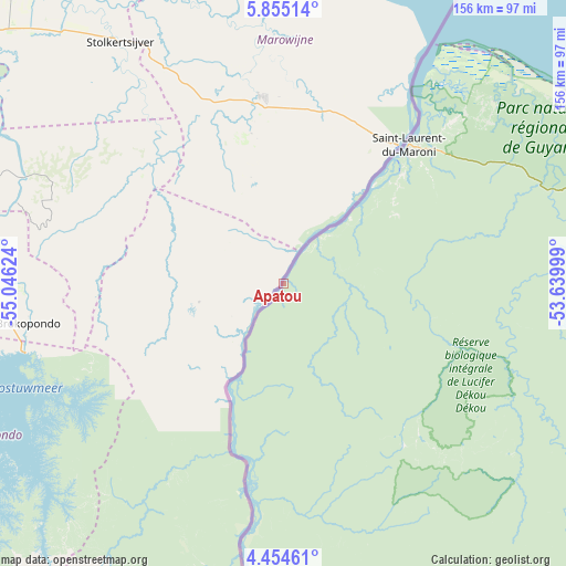
Apatou GPS coordinates[2]
5° 9' 18.936" North, 54° 20' 35.196" West
| Map corner | latitude | longitude |
|---|---|---|
| Upper-left | 5.85514°, | -55.04624° |
| Center: | 5.15526°, | -54.34311° |
| Lower-right: | 4.45461°, | -53.63999° |
| Map W x H: | 155.7×155.7 km | = 96.7×96.7mi |
| max Lat: | 5.66906° ⇑29.4% North |
| Apatou: | 5.15526° |
| min Lat: | ⇓70.6% South 3.16887° |
| min Long | Apatou | max Long |
| -54.38146° | -54.34311° | -51.80243° |
| W 5.9%⇐ | ⇒94.1% E |
Elevation
Elevation of Apatou is 15 m = 49 ft, and this is 8.9 m = 29 ft below average elevation for this country.
| Max E: |
106 m = 348 ft | 29.4% |
| Avg. | 23.9 m = 78 ft | |
| Apatou | 15 m = 49 ft | |
Min E: |
1 m = 3 ft | 70.6% |
See also: French Guiana elevation on elevation.city.
Geographical zone
Apatou is located in North Torrid zone (between Equator and Tropic of Cancer). Distance of Equator is 573.2 km =356.2 mi to South.| Distance of | km | miles | from Apatou |
|---|---|---|---|
| North Pole | 9433.9 | 5862 | to North |
| Arctic Circle | 6828 | 4242.7 | to North |
| Tropic Cancer | 2032.7 | 1263.1 | to North |
| Equator | 573.2 | 356.2 | to South |


Nearby cities:
15 places around Apatou: (largest is in red/bold)
• Cayenne
224 km =139.2 mi,  96°
96°
• Grand-Santi
98.2 km =61 mi,  182°
182°
• Iracoubo
131 km =81.4 mi,  74°
74°
• Kourou
188.3 km =117 mi,  89°
89°
• Macouria
219.7 km =136.5 mi, 97°
• Mana
84.6 km =52.6 mi,  47°
47°
• Maripasoula
171.8 km =106.8 mi,  168°
168°
• Matoury
226.3 km =140.6 mi, 98°
• Roura
228.5 km =142 mi, 101°
• Régina
262.4 km =163 mi,  110°
110°
• Rémire
230.6 km =143.3 mi, 97°
• Rémire-Montjoly
231.5 km =143.8 mi, 96°
• Saint-Laurent-du-Maroni
51.9 km =32.2 mi,  42°
42°
• Sinnamary
155.5 km =96.6 mi,  80°
80°
• Tonate
207.8 km =129.1 mi, 94°
Sources, notices
• [Note1] Compared only with cities in French Guiana existing in our database
• [Src1] Map data: © OpenStreetMap contributors (CC-BY-SA)
• [Src2] Other city data from geonames.org with taken over terms of usage.
• [Src3] Geographical zone / Annual Mean Temperature by Robert A. Rohde @ Wikipedia
