Grand-Santi geodata
Grand-Santi (Guyane) is a populated place; located in French Guiana in America/Cayenne (GMT-3) time zone. With population of 3,941 people, there are 8 cities with bigger population in this country. Compared to other cities in French Guiana, 82.4% of cities are located further ↑North; 100% of cities are located further →East and 82.4% of cities have lower elevation than Grand-Santi. Note1
Administrative division(s):
- Level 1: Guyane
- Level 2: Guyane
- Level 3: Arrondissement de Saint-Laurent-du-Maroni
- Level 4: Grand-Santi


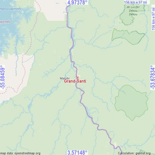
Grand-Santi GPS coordinates[2]
4° 16' 22.62" North, 54° 22' 53.256" West
| Map corner | latitude | longitude |
|---|---|---|
| Upper-left | 4.97378°, | -55.08459° |
| Center: | 4.27295°, | -54.38146° |
| Lower-right: | 3.57148°, | -53.67834° |
| Map W x H: | 155.9×155.9 km | = 96.9×96.9mi |
| max Lat: | 5.66906° ⇑82.4% North |
| Grand-Santi: | 4.27295° |
| min Lat: | ⇓17.6% South 3.16887° |
| min Long | Grand-Santi | max Long |
| -54.38146° | -54.38146° | -51.80243° |
| W 0%⇐ | ⇒100% E |
Elevation
Elevation of Grand-Santi is 52 m = 171 ft, and this is 28.1 m = 92 ft above average elevation for this country.
| Max E: |
106 m = 348 ft | 17.6% |
| Grand-Santi | 52 m 171 ft | |
| Avg. | 23.9 m = 78 ft | |
Min E: |
1 m = 3 ft | 82.4% |
See also: French Guiana elevation on elevation.city.
Geographical zone
Grand-Santi is located in North Torrid zone (between Equator and Tropic of Cancer). Distance of Equator is 475.1 km =295.2 mi to South.| Distance of | km | miles | from Grand-Santi |
|---|---|---|---|
| North Pole | 9532 | 5922.9 | to North |
| Arctic Circle | 6926.1 | 4303.7 | to North |
| Tropic Cancer | 2130.8 | 1324 | to North |
| Equator | 475.1 | 295.2 | to South |


Nearby cities:
15 places around Grand-Santi: (largest is in red/bold)
• Apatou
98.2 km =61 mi,  2°
2°
• Cayenne
238.6 km =148.3 mi,  72°
72°
• Iracoubo
187 km =116.2 mi,  44°
44°
• Kourou
216.6 km =134.6 mi,  62°
62°
• Macouria
233.5 km =145.1 mi, 72°
• Mana
169 km =105 mi,  23°
23°
• Maripasoula
80.2 km =49.8 mi,  151°
151°
• Matoury
236.9 km =147.2 mi, 74°
• Roura
233.5 km =145.1 mi,  77°
77°
• Régina
249.6 km =155.1 mi,  88°
88°
• Rémire
242.8 km =150.9 mi, 73°
• Rémire-Montjoly
245.1 km =152.3 mi, 73°
• Saint-Laurent-du-Maroni
142.1 km =88.3 mi, 15°
• Sinnamary
199.9 km =124.2 mi,  52°
52°
• Tonate
227 km =141.1 mi, 68°
Sources, notices
• [Note1] Compared only with cities in French Guiana existing in our database
• [Src1] Map data: © OpenStreetMap contributors (CC-BY-SA)
• [Src2] Other city data from geonames.org with taken over terms of usage.
• [Src3] Geographical zone / Annual Mean Temperature by Robert A. Rohde @ Wikipedia
