Rémire geodata
Rémire (Guyane) is a seat of a third-order administrative division; located in French Guiana in America/Cayenne (GMT-3) time zone. In our database, there are 14 cities with bigger population. Compared to other cities in French Guiana, 58.8% of cities are located further ↑North; 82.4% of cities are located further ←West and 94.1% of cities have lower elevation than Rémire. Note1
Administrative division(s):
- Level 1: Guyane
- Level 2: Guyane
- Level 3: Arrondissement de Cayenne
- Level 4: Remire-Montjoly


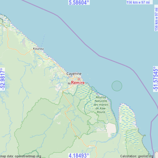
Rémire GPS coordinates[2]
4° 53' 9.06" North, 52° 16' 42.852" West
| Map corner | latitude | longitude |
|---|---|---|
| Upper-left | 5.58604°, | -52.9817° |
| Center: | 4.88585°, | -52.27857° |
| Lower-right: | 4.18493°, | -51.57545° |
| Map W x H: | 155.8×155.8 km | = 96.8×96.8mi |
| max Lat: | 5.66906° ⇑58.8% North |
| Rémire: | 4.88585° |
| min Lat: | ⇓41.2% South 3.16887° |
| min Long | Rémire | max Long |
| -54.38146° | -52.27857° | -51.80243° |
| W 82.4%⇐ | ⇒17.6% E |
Elevation
Elevation of Rémire is 77 m = 253 ft, and this is 53.1 m = 174 ft above average elevation for this country.
| Max E: |
106 m = 348 ft | 5.9% |
| Rémire | 77 m 253 ft | |
| Avg. | 23.9 m = 78 ft | |
Min E: |
1 m = 3 ft | 94.1% |
See also: French Guiana elevation on elevation.city.
Geographical zone
Rémire is located in North Torrid zone (between Equator and Tropic of Cancer). Distance of Equator is 543.3 km =337.6 mi to South.| Distance of | km | miles | from Rémire |
|---|---|---|---|
| North Pole | 9463.8 | 5880.5 | to North |
| Arctic Circle | 6857.9 | 4261.3 | to North |
| Tropic Cancer | 2062.7 | 1281.7 | to North |
| Equator | 543.3 | 337.6 | to South |


Nearby cities:
15 places around Rémire: (largest is in red/bold)
• Apatou
230.6 km =143.3 mi,  277°
277°
• Camopi
191 km =118.7 mi,  181°
181°
• Cayenne
8 km =5 mi,  311°
311°
• Iracoubo
122 km =75.8 mi,  302°
302°
• Kourou
50.7 km =31.5 mi, 307°
• Macouria
11 km =6.8 mi,  285°
285°
• Mana
187.6 km =116.6 mi, 297°
• Matoury
6.4 km =4 mi,  230°
230°
• Roura
18.2 km =11.3 mi,  196°
196°
• Régina
65.8 km =40.9 mi,  165°
165°
• Rémire-Montjoly
3.7 km =2.3 mi,  21°
21°
• Saint-Georges
122.8 km =76.3 mi,  154°
154°
• Saint-Laurent-du-Maroni
205.6 km =127.8 mi, 289°
• Sinnamary
92.8 km =57.7 mi, 306°
• Tonate
25.6 km =15.9 mi, 303°
Sources, notices
• [Note1] Compared only with cities in French Guiana existing in our database
• [Src1] Map data: © OpenStreetMap contributors (CC-BY-SA)
• [Src2] Other city data from geonames.org with taken over terms of usage.
• [Src3] Geographical zone / Annual Mean Temperature by Robert A. Rohde @ Wikipedia
