Régina geodata
Régina (Guyane) is a seat of a third-order administrative division; located in French Guiana in America/Cayenne (GMT-3) time zone. In our database, there are 14 cities with bigger population. Compared to other cities in French Guiana, 76.5% of cities are located further ↑North; 94.1% of cities are located further ←West and 94.1% of cities have higher elevation than Régina. Note1
Administrative division(s):
- Level 1: Guyane
- Level 2: Guyane
- Level 3: Arrondissement de Cayenne
- Level 4: Régina


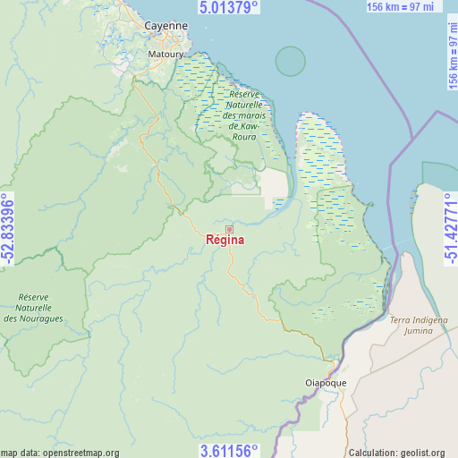
Régina GPS coordinates[2]
4° 18' 46.8" North, 52° 7' 50.988" West
| Map corner | latitude | longitude |
|---|---|---|
| Upper-left | 5.01379°, | -52.83396° |
| Center: | 4.313°, | -52.13083° |
| Lower-right: | 3.61156°, | -51.42771° |
| Map W x H: | 155.9×155.9 km | = 96.9×96.9mi |
| max Lat: | 5.66906° ⇑76.5% North |
| Régina: | 4.313° |
| min Lat: | ⇓23.5% South 3.16887° |
| min Long | Régina | max Long |
| -54.38146° | -52.13083° | -51.80243° |
| W 94.1%⇐ | ⇒5.9% E |
Elevation
Elevation of Régina is 5 m = 16 ft, and this is 18.9 m = 62 ft below average elevation for this country.
| Max E: |
106 m = 348 ft | 94.1% |
| Avg. | 23.9 m = 78 ft | |
| Régina | 5 m = 16 ft | |
Min E: |
1 m = 3 ft | 5.9% |
See also: French Guiana elevation on elevation.city.
Geographical zone
Régina is located in North Torrid zone (between Equator and Tropic of Cancer). Distance of Equator is 479.6 km =298 mi to South.| Distance of | km | miles | from Régina |
|---|---|---|---|
| North Pole | 9527.5 | 5920.1 | to North |
| Arctic Circle | 6921.6 | 4300.9 | to North |
| Tropic Cancer | 2126.4 | 1321.3 | to North |
| Equator | 479.6 | 298 | to South |


Nearby cities:
15 places around Régina: (largest is in red/bold)
• Camopi
129.2 km =80.3 mi,  190°
190°
• Cayenne
72.5 km =45 mi,  341°
341°
• Iracoubo
176 km =109.4 mi,  317°
317°
• Kourou
110.2 km =68.5 mi,  329°
329°
• Macouria
71.9 km =44.7 mi, 337°
• Mana
236.8 km =147.1 mi,  309°
309°
• Maripasoula
223.7 km =139 mi,  250°
250°
• Matoury
63.3 km =39.3 mi, 340°
• Roura
51 km =31.7 mi, 335°
• Rémire
65.8 km =40.9 mi,  345°
345°
• Rémire-Montjoly
68.8 km =42.8 mi, 347°
• Saint-Georges
59.6 km =37 mi,  142°
142°
• Saint-Laurent-du-Maroni
248.4 km =154.3 mi,  302°
302°
• Sinnamary
149.5 km =92.9 mi, 322°
• Tonate
86.4 km =53.7 mi, 334°
Sources, notices
• [Note1] Compared only with cities in French Guiana existing in our database
• [Src1] Map data: © OpenStreetMap contributors (CC-BY-SA)
• [Src2] Other city data from geonames.org with taken over terms of usage.
• [Src3] Geographical zone / Annual Mean Temperature by Robert A. Rohde @ Wikipedia
