Matoury geodata
Matoury (Guyane) is a seat of a third-order administrative division; located in French Guiana in America/Cayenne (GMT-3) time zone. With population of 26,350 people, there is 1 city with bigger population in this country. Compared to other cities in French Guiana, 64.7% of cities are located further ↑North; 76.5% of cities are located further ←West and 76.5% of cities have lower elevation than Matoury. Note1
Administrative division(s):
- Level 1: Guyane
- Level 2: Guyane
- Level 3: Arrondissement de Cayenne
- Level 4: Matoury


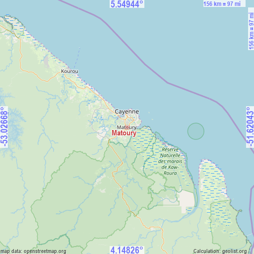
Matoury GPS coordinates[2]
4° 50' 57.156" North, 52° 19' 24.78" West
| Map corner | latitude | longitude |
|---|---|---|
| Upper-left | 5.54944°, | -53.02668° |
| Center: | 4.84921°, | -52.32355° |
| Lower-right: | 4.14826°, | -51.62043° |
| Map W x H: | 155.8×155.8 km | = 96.8×96.8mi |
| max Lat: | 5.66906° ⇑64.7% North |
| Matoury: | 4.84921° |
| min Lat: | ⇓35.3% South 3.16887° |
| min Long | Matoury | max Long |
| -54.38146° | -52.32355° | -51.80243° |
| W 76.5%⇐ | ⇒23.5% E |
Elevation
Elevation of Matoury is 28 m = 92 ft, and this is 4.1 m = 13 ft above average elevation for this country.
| Max E: |
106 m = 348 ft | 23.5% |
| Matoury | 28 m 92 ft | |
| Avg. | 23.9 m = 78 ft | |
Min E: |
1 m = 3 ft | 76.5% |
See also: French Guiana elevation on elevation.city.
Geographical zone
Matoury is located in North Torrid zone (between Equator and Tropic of Cancer). Distance of Equator is 539.2 km =335 mi to South.| Distance of | km | miles | from Matoury |
|---|---|---|---|
| North Pole | 9467.9 | 5883.1 | to North |
| Arctic Circle | 6862 | 4263.8 | to North |
| Tropic Cancer | 2066.7 | 1284.2 | to North |
| Equator | 539.2 | 335 | to South |


Nearby cities:
15 places around Matoury: (largest is in red/bold)
• Apatou
226.3 km =140.6 mi,  278°
278°
• Camopi
186.8 km =116.1 mi,  180°
180°
• Cayenne
9.4 km =5.8 mi,  353°
353°
• Iracoubo
120.2 km =74.7 mi,  305°
305°
• Kourou
49.7 km =30.9 mi, 314°
• Macouria
9 km =5.6 mi,  321°
321°
• Mana
185.1 km =115 mi,  299°
299°
• Roura
13.4 km =8.3 mi, 180°
• Régina
63.3 km =39.3 mi,  160°
160°
• Rémire
6.4 km =4 mi,  50°
50°
• Rémire-Montjoly
9.8 km =6.1 mi,  40°
40°
• Saint-Georges
121.4 km =75.4 mi,  151°
151°
• Saint-Laurent-du-Maroni
202.3 km =125.7 mi,  291°
291°
• Sinnamary
91.4 km =56.8 mi, 309°
• Tonate
24.5 km =15.2 mi, 317°
Sources, notices
• [Note1] Compared only with cities in French Guiana existing in our database
• [Src1] Map data: © OpenStreetMap contributors (CC-BY-SA)
• [Src2] Other city data from geonames.org with taken over terms of usage.
• [Src3] Geographical zone / Annual Mean Temperature by Robert A. Rohde @ Wikipedia
