Mana geodata
Mana (Guyane) is a seat of a third-order administrative division; located in French Guiana in America/Cayenne (GMT-3) time zone. With population of 5,885 people, there are 6 cities with bigger population in this country. Compared to other cities in French Guiana, 100% of cities are located further ↓South; 76.5% of cities are located further →East and 100% of cities have higher elevation than Mana. Note1
Administrative division(s):
- Level 1: Guyane
- Level 2: Guyane
- Level 3: Arrondissement de Saint-Laurent-du-Maroni
- Level 4: Mana


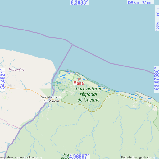
Mana GPS coordinates[2]
5° 40' 8.616" North, 53° 46' 44.292" West
| Map corner | latitude | longitude |
|---|---|---|
| Upper-left | 6.3683°, | -54.4821° |
| Center: | 5.66906°, | -53.77897° |
| Lower-right: | 4.96897°, | -53.07585° |
| Map W x H: | 155.6×155.6 km | = 96.7×96.7mi |
| max Lat: | 5.66906° ⇑0% North |
| Mana: | 5.66906° |
| min Lat: | ⇓100% South 3.16887° |
| min Long | Mana | max Long |
| -54.38146° | -53.77897° | -51.80243° |
| W 23.5%⇐ | ⇒76.5% E |
Elevation
Elevation of Mana is 1 m = 3 ft, and this is 22.9 m = 75 ft below average elevation for this country.
| Max E: |
106 m = 348 ft | 100% |
| Avg. | 23.9 m = 78 ft | |
| Mana | 1 m = 3 ft | |
Min E: |
1 m = 3 ft | 0% |
See also: French Guiana elevation on elevation.city.
Geographical zone
Mana is located in North Torrid zone (between Equator and Tropic of Cancer). Distance of Equator is 630.3 km =391.7 mi to South.| Distance of | km | miles | from Mana |
|---|---|---|---|
| North Pole | 9376.7 | 5826.4 | to North |
| Arctic Circle | 6770.8 | 4207.2 | to North |
| Tropic Cancer | 1975.6 | 1227.6 | to North |
| Equator | 630.3 | 391.7 | to South |


Nearby cities:
15 places around Mana: (largest is in red/bold)
• Apatou
84.6 km =52.6 mi,  227°
227°
• Cayenne
179.7 km =111.7 mi,  117°
117°
• Grand-Santi
169 km =105 mi,  203°
203°
• Iracoubo
66.9 km =41.6 mi,  108°
108°
• Kourou
137.8 km =85.6 mi, 114°
• Macouria
176.8 km =109.9 mi, 118°
• Maripasoula
227.2 km =141.2 mi,  187°
187°
• Matoury
185.1 km =115 mi, 119°
• Roura
192 km =119.3 mi, 122°
• Régina
236.8 km =147.1 mi,  129°
129°
• Rémire
187.6 km =116.6 mi, 117°
• Rémire-Montjoly
187.2 km =116.3 mi, 116°
• Saint-Laurent-du-Maroni
33.4 km =20.8 mi,  236°
236°
• Sinnamary
96.6 km =60 mi, 109°
• Tonate
162.1 km =100.7 mi, 116°
Sources, notices
• [Note1] Compared only with cities in French Guiana existing in our database
• [Src1] Map data: © OpenStreetMap contributors (CC-BY-SA)
• [Src2] Other city data from geonames.org with taken over terms of usage.
• [Src3] Geographical zone / Annual Mean Temperature by Robert A. Rohde @ Wikipedia
