Quebo geodata
Quebo (Tombali) is a populated place; located in Guinea-Bissau in Africa/Bissau (GMT+0) time zone. With population of 7,072 people, there are 10 cities with bigger population in this country. Compared to other cities in Guinea-Bissau, 87.5% of cities are located further ↑North; 75% of cities are located further ←West and 56.3% of cities have lower elevation than Quebo. Note1


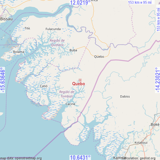
Quebo GPS coordinates[2]
11° 19' 59.988" North, 14° 55' 59.988" West
| Map corner | latitude | longitude |
|---|---|---|
| Upper-left | 12.0219°, | -15.63646° |
| Center: | 11.33333°, | -14.93333° |
| Lower-right: | 10.6431°, | -14.23021° |
| Map W x H: | 153.3×153.3 km | = 95.3×95.3mi |
| max Lat: | 12.66286° ⇑87.5% North |
| Quebo: | 11.33333° |
| min Lat: | ⇓12.5% South 11.2825° |
| min Long | Quebo | max Long |
| -16.16528° | -14.93333° | -13.95343° |
| W 75%⇐ | ⇒25% E |
Elevation
Elevation of Quebo is 22 m = 72 ft, and this is 5.4 m = 18 ft below average elevation for this country.
| Max E: |
64 m = 210 ft | 43.7% |
| Avg. | 27.4 m = 90 ft | |
| Quebo | 22 m = 72 ft | |
Min E: |
8 m = 26 ft | 56.3% |
See also: Guinea-Bissau elevation on elevation.city.
Geographical zone
Quebo is located in North Torrid zone (between Equator and Tropic of Cancer). Distance of Equator is 1260.1 km =783 mi to South.| Distance of | km | miles | from Quebo |
|---|---|---|---|
| North Pole | 8746.9 | 5435.1 | to North |
| Arctic Circle | 6141 | 3815.8 | to North |
| Tropic Cancer | 1345.8 | 836.2 | to North |
| Equator | 1260.1 | 783 | to South |


Nearby cities:
15 places around Quebo: (largest is in red/bold)
• Bafatá
97.2 km =60.4 mi,  17°
17°
• Bissau
93.3 km =58 mi,  309°
309°
• Bissorã
113.7 km =70.6 mi,  330°
330°
• Bolama
65.1 km =40.5 mi,  294°
294°
• Buba
29.2 km =18.1 mi,  346°
346°
• Bubaque
98.3 km =61.1 mi,  266°
266°
• Cacheu
170.1 km =105.7 mi, 307°
• Canchungo
144.9 km =90 mi,  304°
304°
• Catió
35.5 km =22.1 mi,  260°
260°
• Farim
131.7 km =81.8 mi, 346°
• Fulacunda
55.7 km =34.6 mi, 332°
• Gabú
130.7 km =81.2 mi,  36°
36°
• Mansôa
92.4 km =57.4 mi, 332°
• Pitche
153.3 km =95.3 mi, 44°
• Quinhámel
117.8 km =73.2 mi, 301°
Sources, notices
• [Note1] Compared only with cities in Guinea-Bissau existing in our database
• [Src1] Map data: © OpenStreetMap contributors (CC-BY-SA)
• [Src2] Other city data from geonames.org with taken over terms of usage.
• [Src3] Geographical zone / Annual Mean Temperature by Robert A. Rohde @ Wikipedia
