Bissau geodata
Bissau is a capital of a political entity; located in Guinea-Bissau in Africa/Bissau (GMT+0) time zone. With population of 388,028 people, there are 0 cities with bigger population in this country. Compared to other cities in Guinea-Bissau, 62.5% of cities are located further ↑North; 75% of cities are located further →East and 93.7% of cities have higher elevation than Bissau. Note1


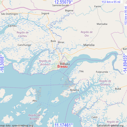
Bissau GPS coordinates[2]
11° 51' 48.852" North, 15° 35' 51.612" West
| Map corner | latitude | longitude |
|---|---|---|
| Upper-left | 12.55079°, | -16.3008° |
| Center: | 11.86357°, | -15.59767° |
| Lower-right: | 11.17461°, | -14.89455° |
| Map W x H: | 153×153 km | = 95.1×95.1mi |
| max Lat: | 12.66286° ⇑62.5% North |
| Bissau: | 11.86357° |
| min Lat: | ⇓37.5% South 11.2825° |
| min Long | Bissau | max Long |
| -16.16528° | -15.59767° | -13.95343° |
| W 25%⇐ | ⇒75% E |
Elevation
Elevation of Bissau is 13 m = 43 ft, and this is 14.4 m = 47 ft below average elevation for this country.
| Max E: |
64 m = 210 ft | 93.7% |
| Avg. | 27.4 m = 90 ft | |
| Bissau | 13 m = 43 ft | |
Min E: |
8 m = 26 ft | 6.3% |
See also: Bissau elevation on elevation.city.
Geographical zone
Bissau is located in North Torrid zone (between Equator and Tropic of Cancer). Distance of this Northern Tropic circle is 1286.8 km =799.6 mi to North.| Distance of | km | miles | from Bissau |
|---|---|---|---|
| North Pole | 8688 | 5398.5 | to North |
| Arctic Circle | 6082.1 | 3779.2 | to North |
| Tropic Cancer | 1286.8 | 799.6 | to North |
| Equator | 1319.1 | 819.7 | to South |


Nearby cities:
15 places around Bissau: (largest is in red/bold)
• Bafatá
107.2 km =66.6 mi,  71°
71°
• Bissorã
43.2 km =26.8 mi,  22°
22°
• Bolama
34.5 km =21.4 mi,  157°
157°
• Buba
72.3 km =44.9 mi,  114°
114°
• Bubaque
69.4 km =43.1 mi,  201°
201°
• Cacheu
76.8 km =47.7 mi,  306°
306°
• Canchungo
52.5 km =32.6 mi,  295°
295°
• Catió
74.6 km =46.4 mi,  149°
149°
• Farim
80.2 km =49.8 mi,  30°
30°
• Fulacunda
47.3 km =29.4 mi,  101°
101°
• Gabú
156.6 km =97.3 mi, 72°
• Mansôa
38.3 km =23.8 mi,  52°
52°
• Pirada
180.3 km =112 mi,  60°
60°
• Quebo
93.3 km =58 mi,  129°
129°
• Quinhámel
28.2 km =17.5 mi,  275°
275°
Sources, notices
• [Note1] Compared only with cities in Guinea-Bissau existing in our database
• [Src1] Map data: © OpenStreetMap contributors (CC-BY-SA)
• [Src2] Other city data from geonames.org with taken over terms of usage.
• [Src3] Geographical zone / Annual Mean Temperature by Robert A. Rohde @ Wikipedia
