Fulacunda geodata
Fulacunda (Quinara) is a seat of a second-order administrative division; located in Guinea-Bissau in Africa/Bissau (GMT+0) time zone. In our database, there are 14 cities with bigger population. Compared to other cities in Guinea-Bissau, 68.7% of cities are located further ↑North; 62.5% of cities are located further ←West and 81.3% of cities have lower elevation than Fulacunda. Note1


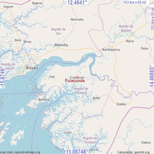
Fulacunda GPS coordinates[2]
11° 46' 35.94" North, 15° 10' 18.372" West
| Map corner | latitude | longitude |
|---|---|---|
| Upper-left | 12.4641°, | -15.8749° |
| Center: | 11.77665°, | -15.17177° |
| Lower-right: | 11.08748°, | -14.46865° |
| Map W x H: | 153.1×153.1 km | = 95.1×95.1mi |
| max Lat: | 12.66286° ⇑68.7% North |
| Fulacunda: | 11.77665° |
| min Lat: | ⇓31.3% South 11.2825° |
| min Long | Fulacunda | max Long |
| -16.16528° | -15.17177° | -13.95343° |
| W 62.5%⇐ | ⇒37.5% E |
Elevation
Elevation of Fulacunda is 43 m = 141 ft, and this is 15.6 m = 51 ft above average elevation for this country.
| Max E: |
64 m = 210 ft | 18.7% |
| Fulacunda | 43 m 141 ft | |
| Avg. | 27.4 m = 90 ft | |
Min E: |
8 m = 26 ft | 81.3% |
See also: Guinea-Bissau elevation on elevation.city.
Geographical zone
Fulacunda is located in North Torrid zone (between Equator and Tropic of Cancer). Distance of this Northern Tropic circle is 1296.5 km =805.6 mi to North.| Distance of | km | miles | from Fulacunda |
|---|---|---|---|
| North Pole | 8697.6 | 5404.4 | to North |
| Arctic Circle | 6091.7 | 3785.2 | to North |
| Tropic Cancer | 1296.5 | 805.6 | to North |
| Equator | 1309.4 | 813.6 | to South |


Nearby cities:
15 places around Fulacunda: (largest is in red/bold)
• Bafatá
70.4 km =43.7 mi,  52°
52°
• Bissau
47.3 km =29.4 mi,  281°
281°
• Bissorã
58 km =36 mi,  328°
328°
• Bolama
39.9 km =24.8 mi,  236°
236°
• Buba
28.3 km =17.6 mi,  137°
137°
• Bubaque
90.6 km =56.3 mi,  232°
232°
• Cacheu
121.4 km =75.4 mi,  297°
297°
• Canchungo
99.1 km =61.6 mi,  289°
289°
• Catió
55.7 km =34.6 mi,  189°
189°
• Farim
78.8 km =49 mi,  356°
356°
• Gabú
117.5 km =73 mi,  61°
61°
• Mansôa
36.7 km =22.8 mi, 334°
• Pitche
145.8 km =90.6 mi,  65°
65°
• Quebo
55.7 km =34.6 mi,  152°
152°
• Quinhámel
75.4 km =46.9 mi, 279°
Sources, notices
• [Note1] Compared only with cities in Guinea-Bissau existing in our database
• [Src1] Map data: © OpenStreetMap contributors (CC-BY-SA)
• [Src2] Other city data from geonames.org with taken over terms of usage.
• [Src3] Geographical zone / Annual Mean Temperature by Robert A. Rohde @ Wikipedia
