Bubaque geodata
Bubaque (Bolama) is a populated place; located in Guinea-Bissau in Africa/Bissau (GMT+0) time zone. With population of 9,244 people, there are 7 cities with bigger population in this country. Compared to other cities in Guinea-Bissau, 93.7% of cities are located further ↑North; 81.2% of cities are located further →East and 68.8% of cities have lower elevation than Bubaque. Note1


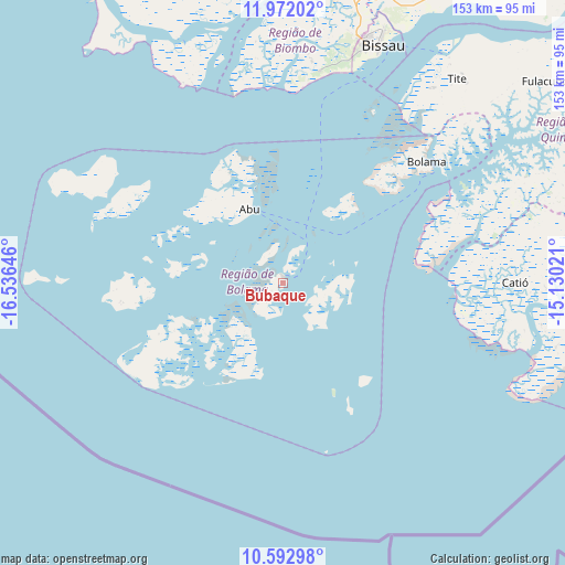
Bubaque GPS coordinates[2]
11° 16' 59.988" North, 15° 49' 59.988" West
| Map corner | latitude | longitude |
|---|---|---|
| Upper-left | 11.97202°, | -16.53646° |
| Center: | 11.28333°, | -15.83333° |
| Lower-right: | 10.59298°, | -15.13021° |
| Map W x H: | 153.3×153.3 km | = 95.3×95.3mi |
| max Lat: | 12.66286° ⇑93.7% North |
| Bubaque: | 11.28333° |
| min Lat: | ⇓6.3% South 11.2825° |
| min Long | Bubaque | max Long |
| -16.16528° | -15.83333° | -13.95343° |
| W 18.8%⇐ | ⇒81.2% E |
Elevation
Elevation of Bubaque is 26 m = 85 ft, and this is 1.4 m = 5 ft below average elevation for this country.
| Max E: |
64 m = 210 ft | 31.2% |
| Avg. | 27.4 m = 90 ft | |
| Bubaque | 26 m = 85 ft | |
Min E: |
8 m = 26 ft | 68.8% |
See also: Guinea-Bissau elevation on elevation.city.
Geographical zone
Bubaque is located in North Torrid zone (between Equator and Tropic of Cancer). Distance of Equator is 1254.6 km =779.6 mi to South.| Distance of | km | miles | from Bubaque |
|---|---|---|---|
| North Pole | 8752.5 | 5438.5 | to North |
| Arctic Circle | 6146.6 | 3819.3 | to North |
| Tropic Cancer | 1351.3 | 839.7 | to North |
| Equator | 1254.6 | 779.6 | to South |


Nearby cities:
15 places around Bubaque: (largest is in red/bold)
• Bafatá
160.9 km =100 mi,  52°
52°
• Bissau
69.4 km =43.1 mi,  21°
21°
• Bissorã
112.6 km =70 mi, 21°
• Bolama
50.8 km =31.6 mi, 50°
• Buba
97.4 km =60.5 mi,  69°
69°
• Cacheu
116 km =72.1 mi,  341°
341°
• Canchungo
89.8 km =55.8 mi,  345°
345°
• Catió
63.1 km =39.2 mi,  90°
90°
• Farim
149.2 km =92.7 mi,  26°
26°
• Fulacunda
90.6 km =56.3 mi, 52°
• Gabú
207.4 km =128.9 mi,  57°
57°
• Mansôa
104.2 km =64.7 mi, 32°
• Pitche
235 km =146 mi, 60°
• Quebo
98.3 km =61.1 mi, 86°
• Quinhámel
67.2 km =41.8 mi,  357°
357°
Sources, notices
• [Note1] Compared only with cities in Guinea-Bissau existing in our database
• [Src1] Map data: © OpenStreetMap contributors (CC-BY-SA)
• [Src2] Other city data from geonames.org with taken over terms of usage.
• [Src3] Geographical zone / Annual Mean Temperature by Robert A. Rohde @ Wikipedia
