Canchungo geodata
Canchungo (Cacheu) is a populated place; located in Guinea-Bissau in Africa/Bissau (GMT+0) time zone. With population of 6,853 people, there are 11 cities with bigger population in this country. Compared to other cities in Guinea-Bissau, 50% of cities are located further ↓South; 93.7% of cities are located further →East and 56.2% of cities have higher elevation than Canchungo. Note1


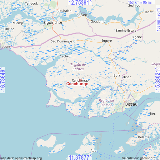
Canchungo GPS coordinates[2]
12° 4' 1.992" North, 16° 1' 59.988" West
| Map corner | latitude | longitude |
|---|---|---|
| Upper-left | 12.75391°, | -16.73646° |
| Center: | 12.06722°, | -16.03333° |
| Lower-right: | 11.37877°, | -15.33021° |
| Map W x H: | 152.9×152.9 km | = 95×95mi |
| max Lat: | 12.66286° ⇑50% North |
| Canchungo: | 12.06722° |
| min Lat: | ⇓50% South 11.2825° |
| min Long | Canchungo | max Long |
| -16.16528° | -16.03333° | -13.95343° |
| W 6.3%⇐ | ⇒93.7% E |
Elevation
Elevation of Canchungo is 21 m = 69 ft, and this is 6.4 m = 21 ft below average elevation for this country.
| Max E: |
64 m = 210 ft | 56.2% |
| Avg. | 27.4 m = 90 ft | |
| Canchungo | 21 m = 69 ft | |
Min E: |
8 m = 26 ft | 43.8% |
See also: Guinea-Bissau elevation on elevation.city.
Geographical zone
Canchungo is located in North Torrid zone (between Equator and Tropic of Cancer). Distance of this Northern Tropic circle is 1264.2 km =785.5 mi to North.| Distance of | km | miles | from Canchungo |
|---|---|---|---|
| North Pole | 8665.3 | 5384.4 | to North |
| Arctic Circle | 6059.4 | 3765.1 | to North |
| Tropic Cancer | 1264.2 | 785.5 | to North |
| Equator | 1341.7 | 833.7 | to South |


Nearby cities:
15 places around Canchungo: (largest is in red/bold)
• Bafatá
149.5 km =92.9 mi,  85°
85°
• Bissau
52.5 km =32.6 mi,  115°
115°
• Bissorã
66 km =41 mi,  74°
74°
• Bolama
81.5 km =50.6 mi,  131°
131°
• Buba
124.8 km =77.5 mi, 115°
• Bubaque
89.8 km =55.8 mi,  165°
165°
• Cacheu
27.1 km =16.8 mi,  328°
328°
• Catió
121.7 km =75.6 mi,  135°
135°
• Farim
99.6 km =61.9 mi,  62°
62°
• Fulacunda
99.1 km =61.6 mi,  109°
109°
• Gabú
198.3 km =123.2 mi,  83°
83°
• Mansôa
77.7 km =48.3 mi, 89°
• Pirada
214.6 km =133.3 mi, 72°
• Quebo
144.9 km =90 mi, 124°
• Quinhámel
27.9 km =17.3 mi, 136°
Sources, notices
• [Note1] Compared only with cities in Guinea-Bissau existing in our database
• [Src1] Map data: © OpenStreetMap contributors (CC-BY-SA)
• [Src2] Other city data from geonames.org with taken over terms of usage.
• [Src3] Geographical zone / Annual Mean Temperature by Robert A. Rohde @ Wikipedia
