Bafatá geodata
Bafatá is a seat of a first-order administrative division; located in Guinea-Bissau in Africa/Bissau (GMT+0) time zone. With population of 22,521 people, there is 1 city with bigger population in this country. Compared to other cities in Guinea-Bissau, 62.5% of cities are located further ↓South; 81.3% of cities are located further ←West and 68.7% of cities have higher elevation than Bafatá. Note1


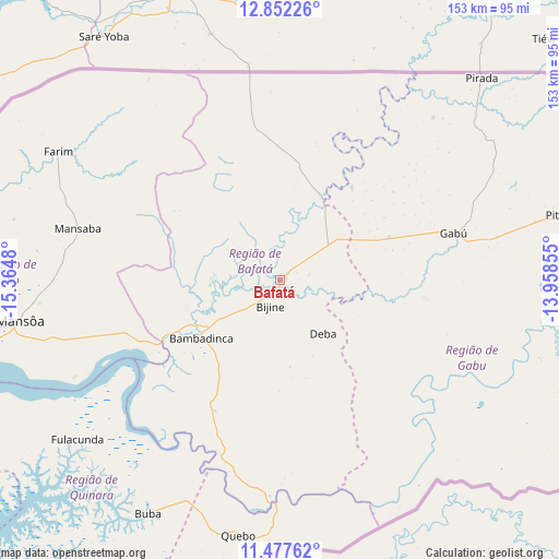
Bafatá GPS coordinates[2]
12° 9' 56.988" North, 14° 39' 42.012" West
| Map corner | latitude | longitude |
|---|---|---|
| Upper-left | 12.85226°, | -15.3648° |
| Center: | 12.16583°, | -14.66167° |
| Lower-right: | 11.47762°, | -13.95855° |
| Map W x H: | 152.8×152.8 km | = 94.9×94.9mi |
| max Lat: | 12.66286° ⇑37.5% North |
| Bafatá: | 12.16583° |
| min Lat: | ⇓62.5% South 11.2825° |
| min Long | Bafatá | max Long |
| -16.16528° | -14.66167° | -13.95343° |
| W 81.3%⇐ | ⇒18.7% E |
Elevation
Elevation of Bafatá is 20 m = 66 ft, and this is 7.4 m = 24 ft below average elevation for this country.
| Max E: |
64 m = 210 ft | 68.7% |
| Avg. | 27.4 m = 90 ft | |
| Bafatá | 20 m = 66 ft | |
Min E: |
8 m = 26 ft | 31.3% |
See also: Guinea-Bissau elevation on elevation.city.
Geographical zone
Bafatá is located in North Torrid zone (between Equator and Tropic of Cancer). Distance of this Northern Tropic circle is 1253.2 km =778.7 mi to North.| Distance of | km | miles | from Bafatá |
|---|---|---|---|
| North Pole | 8654.3 | 5377.5 | to North |
| Arctic Circle | 6048.5 | 3758.4 | to North |
| Tropic Cancer | 1253.2 | 778.7 | to North |
| Equator | 1352.7 | 840.5 | to South |


Nearby cities:
15 places around Bafatá: (largest is in red/bold)
• Bissau
107.2 km =66.6 mi,  251°
251°
• Bissorã
85.6 km =53.2 mi,  274°
274°
• Bolama
110.2 km =68.5 mi,  233°
233°
• Buba
73.7 km =45.8 mi,  209°
209°
• Bubaque
160.9 km =100 mi, 232°
• Canchungo
149.5 km =92.9 mi, 265°
• Catió
117.5 km =73 mi, 213°
• Farim
70.4 km =43.7 mi,  300°
300°
• Fulacunda
70.4 km =43.7 mi, 232°
• Gabú
49.4 km =30.7 mi,  75°
75°
• Mansôa
72.2 km =44.9 mi,  261°
261°
• Pirada
78 km =48.5 mi,  44°
44°
• Pitche
78.9 km =49 mi, 77°
• Quebo
97.2 km =60.4 mi,  197°
197°
• Quinhámel
133.5 km =83 mi, 256°
Sources, notices
• [Note1] Compared only with cities in Guinea-Bissau existing in our database
• [Src1] Map data: © OpenStreetMap contributors (CC-BY-SA)
• [Src2] Other city data from geonames.org with taken over terms of usage.
• [Src3] Geographical zone / Annual Mean Temperature by Robert A. Rohde @ Wikipedia
