Buba geodata
Buba (Quinara) is a seat of a first-order administrative division; located in Guinea-Bissau in Africa/Bissau (GMT+0) time zone. With population of 7,779 people, there are 9 cities with bigger population in this country. Compared to other cities in Guinea-Bissau, 75% of cities are located further ↑North; 68.8% of cities are located further ←West and 68.7% of cities have higher elevation than Buba. Note1


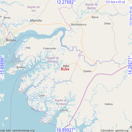
Buba GPS coordinates[2]
11° 35' 20.004" North, 14° 59' 44.988" West
| Map corner | latitude | longitude |
|---|---|---|
| Upper-left | 12.27682°, | -15.69896° |
| Center: | 11.58889°, | -14.99583° |
| Lower-right: | 10.89927°, | -14.29271° |
| Map W x H: | 153.2×153.2 km | = 95.2×95.2mi |
| max Lat: | 12.66286° ⇑75% North |
| Buba: | 11.58889° |
| min Lat: | ⇓25% South 11.2825° |
| min Long | Buba | max Long |
| -16.16528° | -14.99583° | -13.95343° |
| W 68.8%⇐ | ⇒31.2% E |
Elevation
Elevation of Buba is 20 m = 66 ft, and this is 7.4 m = 24 ft below average elevation for this country.
| Max E: |
64 m = 210 ft | 68.7% |
| Avg. | 27.4 m = 90 ft | |
| Buba | 20 m = 66 ft | |
Min E: |
8 m = 26 ft | 31.3% |
See also: Guinea-Bissau elevation on elevation.city.
Geographical zone
Buba is located in North Torrid zone (between Equator and Tropic of Cancer). Distance of Equator is 1288.6 km =800.7 mi to South.| Distance of | km | miles | from Buba |
|---|---|---|---|
| North Pole | 8718.5 | 5417.4 | to North |
| Arctic Circle | 6112.6 | 3798.2 | to North |
| Tropic Cancer | 1317.4 | 818.6 | to North |
| Equator | 1288.6 | 800.7 | to South |


Nearby cities:
15 places around Buba: (largest is in red/bold)
• Bafatá
73.7 km =45.8 mi,  29°
29°
• Bissau
72.3 km =44.9 mi,  294°
294°
• Bissorã
85.9 km =53.4 mi,  325°
325°
• Bolama
52.3 km =32.5 mi,  268°
268°
• Bubaque
97.4 km =60.5 mi,  249°
249°
• Cacheu
148.3 km =92.1 mi,  300°
300°
• Canchungo
124.8 km =77.5 mi, 295°
• Catió
44.2 km =27.5 mi,  219°
219°
• Farim
102.5 km =63.7 mi,  346°
346°
• Fulacunda
28.3 km =17.6 mi,  317°
317°
• Gabú
114 km =70.8 mi,  47°
47°
• Mansôa
64.3 km =40 mi, 326°
• Pitche
139.7 km =86.8 mi, 54°
• Quebo
29.2 km =18.1 mi,  166°
166°
• Quinhámel
99.3 km =61.7 mi, 289°
Sources, notices
• [Note1] Compared only with cities in Guinea-Bissau existing in our database
• [Src1] Map data: © OpenStreetMap contributors (CC-BY-SA)
• [Src2] Other city data from geonames.org with taken over terms of usage.
• [Src3] Geographical zone / Annual Mean Temperature by Robert A. Rohde @ Wikipedia
