Mansôa geodata
Mansôa (Oio) is a populated place; located in Guinea-Bissau in Africa/Bissau (GMT+0) time zone. With population of 7,821 people, there are 8 cities with bigger population in this country. Compared to other cities in Guinea-Bissau, 56.3% of cities are located further ↓South; 56.2% of cities are located further →East and 87.5% of cities have higher elevation than Mansôa. Note1


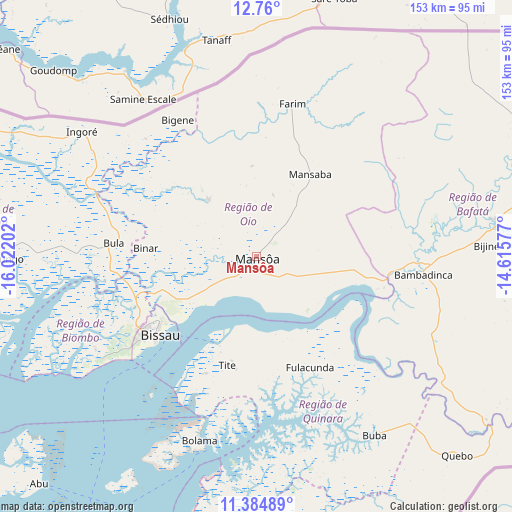
Mansôa GPS coordinates[2]
12° 4' 23.988" North, 15° 19' 8.004" West
| Map corner | latitude | longitude |
|---|---|---|
| Upper-left | 12.76°, | -16.02202° |
| Center: | 12.07333°, | -15.31889° |
| Lower-right: | 11.38489°, | -14.61577° |
| Map W x H: | 152.9×152.9 km | = 95×95mi |
| max Lat: | 12.66286° ⇑43.7% North |
| Mansôa: | 12.07333° |
| min Lat: | ⇓56.3% South 11.2825° |
| min Long | Mansôa | max Long |
| -16.16528° | -15.31889° | -13.95343° |
| W 43.8%⇐ | ⇒56.2% E |
Elevation
Elevation of Mansôa is 14 m = 46 ft, and this is 13.4 m = 44 ft below average elevation for this country.
| Max E: |
64 m = 210 ft | 87.5% |
| Avg. | 27.4 m = 90 ft | |
| Mansôa | 14 m = 46 ft | |
Min E: |
8 m = 26 ft | 12.5% |
See also: Guinea-Bissau elevation on elevation.city.
Geographical zone
Mansôa is located in North Torrid zone (between Equator and Tropic of Cancer). Distance of this Northern Tropic circle is 1263.5 km =785.1 mi to North.| Distance of | km | miles | from Mansôa |
|---|---|---|---|
| North Pole | 8664.6 | 5383.9 | to North |
| Arctic Circle | 6058.7 | 3764.7 | to North |
| Tropic Cancer | 1263.5 | 785.1 | to North |
| Equator | 1342.4 | 834.1 | to South |


Nearby cities:
15 places around Mansôa: (largest is in red/bold)
• Bafatá
72.2 km =44.9 mi,  81°
81°
• Bissau
38.3 km =23.8 mi,  232°
232°
• Bissorã
21.7 km =13.5 mi,  319°
319°
• Bolama
57.8 km =35.9 mi,  197°
197°
• Buba
64.3 km =40 mi,  146°
146°
• Bubaque
104.2 km =64.7 mi,  212°
212°
• Cacheu
94.7 km =58.8 mi,  283°
283°
• Canchungo
77.7 km =48.3 mi,  269°
269°
• Catió
88.2 km =54.8 mi,  175°
175°
• Farim
46.9 km =29.1 mi,  13°
13°
• Fulacunda
36.7 km =22.8 mi, 154°
• Gabú
121.4 km =75.4 mi, 79°
• Pirada
142.5 km =88.5 mi,  62°
62°
• Quebo
92.4 km =57.4 mi, 152°
• Quinhámel
61.9 km =38.5 mi,  250°
250°
Sources, notices
• [Note1] Compared only with cities in Guinea-Bissau existing in our database
• [Src1] Map data: © OpenStreetMap contributors (CC-BY-SA)
• [Src2] Other city data from geonames.org with taken over terms of usage.
• [Src3] Geographical zone / Annual Mean Temperature by Robert A. Rohde @ Wikipedia
