Bissorã geodata
Bissorã (Oio) is a populated place; located in Guinea-Bissau in Africa/Bissau (GMT+0) time zone. With population of 12,688 people, there are 3 cities with bigger population in this country. Compared to other cities in Guinea-Bissau, 68.8% of cities are located further ↓South; 62.5% of cities are located further →East and 68.8% of cities have lower elevation than Bissorã. Note1


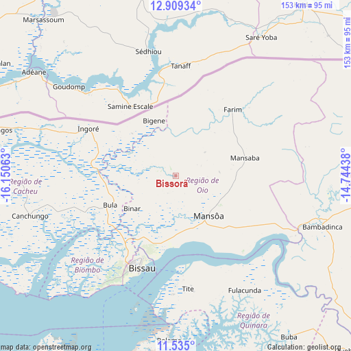
Bissorã GPS coordinates[2]
12° 13' 23.016" North, 15° 26' 51" West
| Map corner | latitude | longitude |
|---|---|---|
| Upper-left | 12.90934°, | -16.15063° |
| Center: | 12.22306°, | -15.4475° |
| Lower-right: | 11.535°, | -14.74438° |
| Map W x H: | 152.8×152.8 km | = 94.9×94.9mi |
| max Lat: | 12.66286° ⇑31.2% North |
| Bissorã: | 12.22306° |
| min Lat: | ⇓68.8% South 11.2825° |
| min Long | Bissorã | max Long |
| -16.16528° | -15.4475° | -13.95343° |
| W 37.5%⇐ | ⇒62.5% E |
Elevation
Elevation of Bissorã is 26 m = 85 ft, and this is 1.4 m = 5 ft below average elevation for this country.
| Max E: |
64 m = 210 ft | 31.2% |
| Avg. | 27.4 m = 90 ft | |
| Bissorã | 26 m = 85 ft | |
Min E: |
8 m = 26 ft | 68.8% |
See also: Guinea-Bissau elevation on elevation.city.
Geographical zone
Bissorã is located in North Torrid zone (between Equator and Tropic of Cancer). Distance of this Northern Tropic circle is 1246.8 km =774.7 mi to North.| Distance of | km | miles | from Bissorã |
|---|---|---|---|
| North Pole | 8648 | 5373.6 | to North |
| Arctic Circle | 6042.1 | 3754.4 | to North |
| Tropic Cancer | 1246.8 | 774.7 | to North |
| Equator | 1359.1 | 844.5 | to South |


Nearby cities:
15 places around Bissorã: (largest is in red/bold)
• Bafatá
85.6 km =53.2 mi,  94°
94°
• Bissau
43.2 km =26.8 mi,  202°
202°
• Bolama
71.9 km =44.7 mi,  182°
182°
• Buba
85.9 km =53.4 mi,  145°
145°
• Bubaque
112.6 km =70 mi, 201°
• Cacheu
78.2 km =48.6 mi,  274°
274°
• Canchungo
66 km =41 mi,  254°
254°
• Catió
106.7 km =66.3 mi,  168°
168°
• Farim
38 km =23.6 mi,  40°
40°
• Fulacunda
58 km =36 mi, 148°
• Gabú
133.3 km =82.8 mi, 87°
• Mansôa
21.7 km =13.5 mi,  139°
139°
• Pirada
148.7 km =92.4 mi,  70°
70°
• Quebo
113.7 km =70.6 mi, 150°
• Quinhámel
58 km =36 mi,  229°
229°
Sources, notices
• [Note1] Compared only with cities in Guinea-Bissau existing in our database
• [Src1] Map data: © OpenStreetMap contributors (CC-BY-SA)
• [Src2] Other city data from geonames.org with taken over terms of usage.
• [Src3] Geographical zone / Annual Mean Temperature by Robert A. Rohde @ Wikipedia
