Bolama geodata
Bolama is a seat of a first-order administrative division; located in Guinea-Bissau in Africa/Bissau (GMT+0) time zone. With population of 10,769 people, there are 4 cities with bigger population in this country. Compared to other cities in Guinea-Bissau, 81.2% of cities are located further ↑North; 68.7% of cities are located further →East and 62.5% of cities have lower elevation than Bolama. Note1


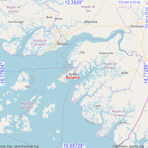
Bolama GPS coordinates[2]
11° 34' 36.984" North, 15° 28' 33.996" West
| Map corner | latitude | longitude |
|---|---|---|
| Upper-left | 12.2649°, | -16.17924° |
| Center: | 11.57694°, | -15.47611° |
| Lower-right: | 10.88729°, | -14.77299° |
| Map W x H: | 153.2×153.2 km | = 95.2×95.2mi |
| max Lat: | 12.66286° ⇑81.2% North |
| Bolama: | 11.57694° |
| min Lat: | ⇓18.8% South 11.2825° |
| min Long | Bolama | max Long |
| -16.16528° | -15.47611° | -13.95343° |
| W 31.3%⇐ | ⇒68.7% E |
Elevation
Elevation of Bolama is 25 m = 82 ft, and this is 2.4 m = 8 ft below average elevation for this country.
| Max E: |
64 m = 210 ft | 37.5% |
| Avg. | 27.4 m = 90 ft | |
| Bolama | 25 m = 82 ft | |
Min E: |
8 m = 26 ft | 62.5% |
See also: Guinea-Bissau elevation on elevation.city.
Geographical zone
Bolama is located in North Torrid zone (between Equator and Tropic of Cancer). Distance of Equator is 1287.2 km =799.8 mi to South.| Distance of | km | miles | from Bolama |
|---|---|---|---|
| North Pole | 8719.8 | 5418.2 | to North |
| Arctic Circle | 6113.9 | 3799 | to North |
| Tropic Cancer | 1318.7 | 819.4 | to North |
| Equator | 1287.2 | 799.8 | to South |


Nearby cities:
15 places around Bolama: (largest is in red/bold)
• Bafatá
110.2 km =68.5 mi,  53°
53°
• Bissau
34.5 km =21.4 mi,  337°
337°
• Bissorã
71.9 km =44.7 mi,  2°
2°
• Buba
52.3 km =32.5 mi,  88°
88°
• Bubaque
50.8 km =31.6 mi,  230°
230°
• Cacheu
107.9 km =67 mi,  315°
315°
• Canchungo
81.5 km =50.6 mi,  311°
311°
• Catió
40.7 km =25.3 mi,  143°
143°
• Farim
104.6 km =65 mi,  15°
15°
• Fulacunda
39.9 km =24.8 mi,  56°
56°
• Gabú
157.2 km =97.7 mi, 60°
• Mansôa
57.8 km =35.9 mi, 17°
• Pitche
185.3 km =115.1 mi, 63°
• Quebo
65.1 km =40.5 mi,  114°
114°
• Quinhámel
53.8 km =33.4 mi, 309°
Sources, notices
• [Note1] Compared only with cities in Guinea-Bissau existing in our database
• [Src1] Map data: © OpenStreetMap contributors (CC-BY-SA)
• [Src2] Other city data from geonames.org with taken over terms of usage.
• [Src3] Geographical zone / Annual Mean Temperature by Robert A. Rohde @ Wikipedia
