Pirada geodata
Pirada (Gabú) is a seat of a second-order administrative division; located in Guinea-Bissau in Africa/Bissau (GMT+0) time zone. In our database, there are 14 cities with bigger population. Compared to other cities in Guinea-Bissau, 100% of cities are located further ↓South; 93.8% of cities are located further ←West and 87.5% of cities have lower elevation than Pirada. Note1


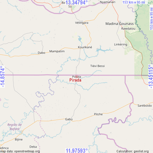
Pirada GPS coordinates[2]
12° 39' 46.296" North, 14° 9' 15.372" West
| Map corner | latitude | longitude |
|---|---|---|
| Upper-left | 13.34794°, | -14.8574° |
| Center: | 12.66286°, | -14.15427° |
| Lower-right: | 11.97593°, | -13.45115° |
| Map W x H: | 152.6×152.6 km | = 94.8×94.8mi |
| max Lat: | 12.66286° ⇑0% North |
| Pirada: | 12.66286° |
| min Lat: | ⇓100% South 11.2825° |
| min Long | Pirada | max Long |
| -16.16528° | -14.15427° | -13.95343° |
| W 93.8%⇐ | ⇒6.2% E |
Elevation
Elevation of Pirada is 47 m = 154 ft, and this is 19.6 m = 64 ft above average elevation for this country.
| Max E: |
64 m = 210 ft | 12.5% |
| Pirada | 47 m 154 ft | |
| Avg. | 27.4 m = 90 ft | |
Min E: |
8 m = 26 ft | 87.5% |
See also: Guinea-Bissau elevation on elevation.city.
Geographical zone
Pirada is located in North Torrid zone (between Equator and Tropic of Cancer). Distance of this Northern Tropic circle is 1197.9 km =744.3 mi to North.| Distance of | km | miles | from Pirada |
|---|---|---|---|
| North Pole | 8599.1 | 5343.2 | to North |
| Arctic Circle | 5993.2 | 3724 | to North |
| Tropic Cancer | 1197.9 | 744.3 | to North |
| Equator | 1408 | 874.9 | to South |


Nearby cities:
15 places around Pirada: (largest is in red/bold)
• Bafatá
78 km =48.5 mi,  224°
224°
• Bissau
180.3 km =112 mi,  240°
240°
• Bissorã
148.7 km =92.4 mi,  250°
250°
• Bolama
187.7 km =116.6 mi,  229°
229°
• Buba
150.4 km =93.5 mi, 217°
• Cacheu
222.6 km =138.3 mi,  258°
258°
• Canchungo
214.6 km =133.3 mi, 252°
• Catió
194.6 km =120.9 mi, 217°
• Farim
117.5 km =73 mi, 260°
• Fulacunda
148.1 km =92 mi, 228°
• Gabú
43.2 km =26.8 mi,  189°
189°
• Mansôa
142.5 km =88.5 mi, 242°
• Pitche
43.6 km =27.1 mi,  149°
149°
• Quebo
170.4 km =105.9 mi,  209°
209°
• Quinhámel
204 km =126.8 mi, 244°
Sources, notices
• [Note1] Compared only with cities in Guinea-Bissau existing in our database
• [Src1] Map data: © OpenStreetMap contributors (CC-BY-SA)
• [Src2] Other city data from geonames.org with taken over terms of usage.
• [Src3] Geographical zone / Annual Mean Temperature by Robert A. Rohde @ Wikipedia
