Kedārnāth geodata
Kedārnāth (Uttarakhand) is a populated place; located in India in Asia/Kolkata (GMT+5.5) time zone. With population of 508 people, there are 3474 cities with bigger population in this country. Compared to other cities in India, 95% of cities are located further ↓South; 59.6% of cities are located further ←West and 99.9% of cities have lower elevation than Kedārnāth. Note1


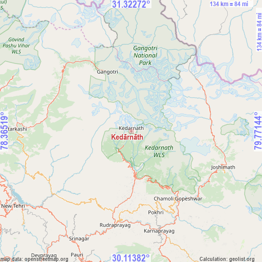
Kedārnāth GPS coordinates[2]
30° 43' 12.576" North, 79° 4' 5.916" East
| Map corner | latitude | longitude |
|---|---|---|
| Upper-left | 31.32272°, | 78.36519° |
| Center: | 30.72016°, | 79.06831° |
| Lower-right: | 30.11382°, | 79.77144° |
| Map W x H: | 134.4×134.4 km | = 83.5×83.5mi |
| max Lat: | 34.9274° ⇑5% North |
| Kedārnāth: | 30.72016° |
| min Lat: | ⇓95% South 8.09008° |
| min Long | Kedārnāth | max Long |
| 68.82655° | 79.06831° | 96.81° |
| W 59.6%⇐ | ⇒40.4% E |
Elevation
Elevation of Kedārnāth is 3430 m = 11253 ft, and this is 3134.4 m = 10283 ft above average elevation for this country.
| Max E: |
3681 m = 12077 ft | 0.099999999999994% |
| Kedārnāth | 3430 m 11253 ft | |
| Avg. | 295.6 m = 970 ft | |
Min E: |
1 m = 3 ft | 99.9% |
See also: India elevation on elevation.city.
Geographical zone
Kedārnāth is located in North temperate zone (between Tropic of Cancer and the Arctic Circle). Distance of this Northern Tropic circle is 809.8 km =503.2 mi to South.| Distance of | km | miles | from Kedārnāth |
|---|---|---|---|
| North Pole | 6591.3 | 4095.6 | to North |
| Arctic Circle | 3985.4 | 2476.4 | to North |
| Tropic Cancer | 809.8 | 503.2 | to South |
| Equator | 3415.8 | 2122.5 | to South |


Nearby cities:
15 places around Kedārnāth: (largest is in red/bold)
• Barkot
83 km =51.6 mi,  276°
276°
• Birbhaddar
104.4 km =64.9 mi,  226°
226°
• Devaprayāg
77.9 km =48.4 mi,  214°
214°
• Gangotri
32.9 km =20.4 mi,  338°
338°
• Joshīmath
50.9 km =31.6 mi,  111°
111°
• Mussoorie
99.9 km =62.1 mi,  252°
252°
• Narendranagar
97.3 km =60.5 mi, 230°
• Pauri
69 km =42.9 mi,  203°
203°
• Pīpalkoti
47.7 km =29.6 mi,  133°
133°
• Rishīkesh
100.8 km =62.6 mi, 227°
• Rudraprayāg
49.1 km =30.5 mi,  189°
189°
• Rāipur
104.2 km =64.7 mi,  244°
244°
• Srīnagar
61.7 km =38.3 mi, 206°
• Tehri
67.2 km =41.8 mi, 236°
• Uttarkāshi
59.7 km =37.1 mi,  271°
271°
Sources, notices
• [Note1] Compared only with cities in India existing in our database
• [Src1] Map data: © OpenStreetMap contributors (CC-BY-SA)
• [Src2] Other city data from geonames.org with taken over terms of usage.
• [Src3] Geographical zone / Annual Mean Temperature by Robert A. Rohde @ Wikipedia
