Gangotri geodata
Gangotri (Uttarakhand) is a populated place; located in India in Asia/Kolkata (GMT+5.5) time zone. With population of 810 people, there are 3468 cities with bigger population in this country. Compared to other cities in India, 95.8% of cities are located further ↓South; 58.6% of cities are located further ←West and 99.9% of cities have lower elevation than Gangotri. Note1


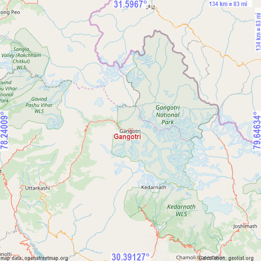
Gangotri GPS coordinates[2]
30° 59' 45.204" North, 78° 56' 35.556" East
| Map corner | latitude | longitude |
|---|---|---|
| Upper-left | 31.5967°, | 78.24009° |
| Center: | 30.99589°, | 78.94321° |
| Lower-right: | 30.39127°, | 79.64634° |
| Map W x H: | 134×134 km | = 83.3×83.3mi |
| max Lat: | 34.9274° ⇑4.2% North |
| Gangotri: | 30.99589° |
| min Lat: | ⇓95.8% South 8.09008° |
| min Long | Gangotri | max Long |
| 68.82655° | 78.94321° | 96.81° |
| W 58.6%⇐ | ⇒41.4% E |
Elevation
Elevation of Gangotri is 3155 m = 10351 ft, and this is 2859.4 m = 9381 ft above average elevation for this country.
| Max E: |
3681 m = 12077 ft | 0.099999999999994% |
| Gangotri | 3155 m 10351 ft | |
| Avg. | 295.6 m = 970 ft | |
Min E: |
1 m = 3 ft | 99.9% |
See also: India elevation on elevation.city.
Geographical zone
Gangotri is located in North temperate zone (between Tropic of Cancer and the Arctic Circle). Distance of this Northern Tropic circle is 840.5 km =522.3 mi to South.| Distance of | km | miles | from Gangotri |
|---|---|---|---|
| North Pole | 6560.6 | 4076.6 | to North |
| Arctic Circle | 3954.8 | 2457.4 | to North |
| Tropic Cancer | 840.5 | 522.3 | to South |
| Equator | 3446.4 | 2141.5 | to South |


Nearby cities:
15 places around Gangotri: (largest is in red/bold)
• Barkot
73.4 km =45.6 mi,  253°
253°
• Chakrāta
108 km =67.1 mi, 252°
• Dehra Dūn
114.6 km =71.2 mi,  229°
229°
• Devaprayāg
100 km =62.1 mi,  199°
199°
• Joshīmath
76.9 km =47.8 mi,  129°
129°
• Kedārnāth
32.9 km =20.4 mi,  158°
158°
• Mussoorie
102.8 km =63.9 mi, 234°
• Narendranagar
112 km =69.6 mi,  214°
214°
• Pauri
95.1 km =59.1 mi,  189°
189°
• Pīpalkoti
78.7 km =48.9 mi,  143°
143°
• Rudraprayāg
79.2 km =49.2 mi,  177°
177°
• Rāipur
111.6 km =69.3 mi, 226°
• Srīnagar
87.3 km =54.2 mi, 190°
• Tehri
80.5 km =50 mi, 213°
• Uttarkāshi
56.1 km =34.9 mi,  238°
238°
Sources, notices
• [Note1] Compared only with cities in India existing in our database
• [Src1] Map data: © OpenStreetMap contributors (CC-BY-SA)
• [Src2] Other city data from geonames.org with taken over terms of usage.
• [Src3] Geographical zone / Annual Mean Temperature by Robert A. Rohde @ Wikipedia
