Bhigvan geodata
Bhigvan (Maharashtra) is a populated place; located in India in Asia/Kolkata (GMT+5.5) time zone. With population of 8,753 people, there are 3061 cities with bigger population in this country. Compared to other cities in India, 71% of cities are located further ↑North; 84.6% of cities are located further →East and 82.5% of cities have lower elevation than Bhigvan. Note1


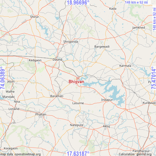
Bhigvan GPS coordinates[2]
18° 18' 2.52" North, 74° 46' 1.236" East
| Map corner | latitude | longitude |
|---|---|---|
| Upper-left | 18.96696°, | 74.06389° |
| Center: | 18.3007°, | 74.76701° |
| Lower-right: | 17.63187°, | 75.47014° |
| Map W x H: | 148.4×148.5 km | = 92.2×92.3mi |
| max Lat: | 34.9274° ⇑71% North |
| Bhigvan: | 18.3007° |
| min Lat: | ⇓29% South 8.09008° |
| min Long | Bhigvan | max Long |
| 68.82655° | 74.76701° | 96.81° |
| W 15.4%⇐ | ⇒84.6% E |
Elevation
Elevation of Bhigvan is 501 m = 1644 ft, and this is 205.4 m = 674 ft above average elevation for this country.
| Max E: |
3681 m = 12077 ft | 17.5% |
| Bhigvan | 501 m 1644 ft | |
| Avg. | 295.6 m = 970 ft | |
Min E: |
1 m = 3 ft | 82.5% |
See also: India elevation on elevation.city.
Geographical zone
Bhigvan is located in North Torrid zone (between Equator and Tropic of Cancer). Distance of this Northern Tropic circle is 571.1 km =354.9 mi to North.| Distance of | km | miles | from Bhigvan |
|---|---|---|---|
| North Pole | 7972.2 | 4953.7 | to North |
| Arctic Circle | 5366.3 | 3334.5 | to North |
| Tropic Cancer | 571.1 | 354.9 | to North |
| Equator | 2034.8 | 1264.4 | to South |


Nearby cities:
15 places around Bhigvan: (largest is in red/bold)
• Ahmadnagar
88.3 km =54.9 mi,  358°
358°
• Bārāmati
26 km =16.2 mi,  230°
230°
• Daund
26.6 km =16.5 mi,  313°
313°
• Jejūri
64.1 km =39.8 mi,  267°
267°
• Kalas
14.5 km =9 mi,  170°
170°
• Karmāla
46.6 km =29 mi,  75°
75°
• Koregaon
83.9 km =52.1 mi,  297°
297°
• Kurduvādi
72.3 km =44.9 mi,  108°
108°
• Mhāsvād
74.2 km =46.1 mi,  178°
178°
• Phaltan
49.4 km =30.7 mi, 225°
• Shirwal
85 km =52.8 mi,  258°
258°
• Shrīgonda
35.7 km =22.2 mi,  348°
348°
• Sirūr
71.7 km =44.6 mi,  324°
324°
• Sāsvad
77.8 km =48.3 mi, 273°
• Ārangaon
80.9 km =50.3 mi, 356°
Sources, notices
• [Note1] Compared only with cities in India existing in our database
• [Src1] Map data: © OpenStreetMap contributors (CC-BY-SA)
• [Src2] Other city data from geonames.org with taken over terms of usage.
• [Src3] Geographical zone / Annual Mean Temperature by Robert A. Rohde @ Wikipedia
