Utraula geodata
Utraula (Uttar Pradesh) is a populated place; located in India in Asia/Kolkata (GMT+5.5) time zone. With population of 28,437 people, there are 1516 cities with bigger population in this country. Compared to other cities in India, 80.9% of cities are located further ↓South; 77.7% of cities are located further ←West and 66.6% of cities have higher elevation than Utraula. Note1


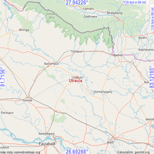
Utraula GPS coordinates[2]
27° 19' 9.588" North, 82° 25' 7.392" East
| Map corner | latitude | longitude |
|---|---|---|
| Upper-left | 27.94226°, | 81.7156° |
| Center: | 27.31933°, | 82.41872° |
| Lower-right: | 26.69288°, | 83.12185° |
| Map W x H: | 138.9×138.9 km | = 86.3×86.3mi |
| max Lat: | 34.9274° ⇑19.1% North |
| Utraula: | 27.31933° |
| min Lat: | ⇓80.9% South 8.09008° |
| min Long | Utraula | max Long |
| 68.82655° | 82.41872° | 96.81° |
| W 77.7%⇐ | ⇒22.3% E |
Elevation
Elevation of Utraula is 109 m = 358 ft, and this is 186.6 m = 612 ft below average elevation for this country.
| Max E: |
3681 m = 12077 ft | 66.6% |
| Avg. | 295.6 m = 970 ft | |
| Utraula | 109 m = 358 ft | |
Min E: |
1 m = 3 ft | 33.4% |
See also: India elevation on elevation.city.
Geographical zone
Utraula is located in North temperate zone (between Tropic of Cancer and the Arctic Circle). Distance of this Northern Tropic circle is 431.7 km =268.2 mi to South.| Distance of | km | miles | from Utraula |
|---|---|---|---|
| North Pole | 6969.4 | 4330.6 | to North |
| Arctic Circle | 4363.5 | 2711.4 | to North |
| Tropic Cancer | 431.7 | 268.2 | to South |
| Equator | 3037.6 | 1887.5 | to South |


Nearby cities:
15 places around Utraula: (largest is in red/bold)
• Ajodhya
61.6 km =38.3 mi,  200°
200°
• Balrāmpur
26.1 km =16.2 mi,  298°
298°
• Bastī
66 km =41 mi,  153°
153°
• Bhinga
64 km =39.8 mi,  311°
311°
• Bānsi
53.4 km =33.2 mi,  107°
107°
• Fyzābād
66.1 km =41.1 mi, 203°
• Gondā City
50.5 km =31.4 mi,  245°
245°
• Haraiya
58.5 km =36.4 mi,  175°
175°
• Ikauna
50.2 km =31.2 mi, 297°
• Katra
44.1 km =27.4 mi, 298°
• Khargupur
43 km =26.7 mi,  278°
278°
• Mankāpur
35.1 km =21.8 mi,  212°
212°
• Nawābganj
57.6 km =35.8 mi, 208°
• Pachperwa
30.8 km =19.1 mi,  45°
45°
• Tulsīpur
23.8 km =14.8 mi,  359°
359°
Sources, notices
• [Note1] Compared only with cities in India existing in our database
• [Src1] Map data: © OpenStreetMap contributors (CC-BY-SA)
• [Src2] Other city data from geonames.org with taken over terms of usage.
• [Src3] Geographical zone / Annual Mean Temperature by Robert A. Rohde @ Wikipedia
