Bhinga geodata
Bhinga (Uttar Pradesh) is a populated place; located in India in Asia/Kolkata (GMT+5.5) time zone. With population of 22,016 people, there are 1904 cities with bigger population in this country. Compared to other cities in India, 83% of cities are located further ↓South; 76.3% of cities are located further ←West and 64.7% of cities have higher elevation than Bhinga. Note1


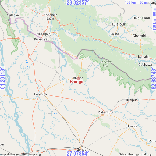
Bhinga GPS coordinates[2]
27° 42' 10.188" North, 81° 56' 3.48" East
| Map corner | latitude | longitude |
|---|---|---|
| Upper-left | 28.32357°, | 81.23118° |
| Center: | 27.70283°, | 81.9343° |
| Lower-right: | 27.07854°, | 82.63743° |
| Map W x H: | 138.4×138.4 km | = 86×86mi |
| max Lat: | 34.9274° ⇑17% North |
| Bhinga: | 27.70283° |
| min Lat: | ⇓83% South 8.09008° |
| min Long | Bhinga | max Long |
| 68.82655° | 81.9343° | 96.81° |
| W 76.3%⇐ | ⇒23.7% E |
Elevation
Elevation of Bhinga is 122 m = 400 ft, and this is 173.6 m = 570 ft below average elevation for this country.
| Max E: |
3681 m = 12077 ft | 64.7% |
| Avg. | 295.6 m = 970 ft | |
| Bhinga | 122 m = 400 ft | |
Min E: |
1 m = 3 ft | 35.3% |
See also: India elevation on elevation.city.
Geographical zone
Bhinga is located in North temperate zone (between Tropic of Cancer and the Arctic Circle). Distance of this Northern Tropic circle is 474.3 km =294.7 mi to South.| Distance of | km | miles | from Bhinga |
|---|---|---|---|
| North Pole | 6926.8 | 4304.1 | to North |
| Arctic Circle | 4320.9 | 2684.9 | to North |
| Tropic Cancer | 474.3 | 294.7 | to South |
| Equator | 3080.3 | 1914 | to South |


Nearby cities:
15 places around Bhinga: (largest is in red/bold)
• Bahraigh
36.4 km =22.6 mi,  246°
246°
• Balrāmpur
39.2 km =24.4 mi,  140°
140°
• Colonelganj
67.4 km =41.9 mi,  200°
200°
• Dhaurahra
89.3 km =55.5 mi,  291°
291°
• Gondā City
63.5 km =39.5 mi,  178°
178°
• Ikauna
19.4 km =12.1 mi,  169°
169°
• Jarwal
71.4 km =44.4 mi,  212°
212°
• Katra
23.4 km =14.5 mi,  157°
157°
• Khargupur
36.7 km =22.8 mi, 171°
• Mankāpur
78 km =48.5 mi, 158°
• Nānpāra
46.3 km =28.8 mi, 292°
• Pachperwa
73 km =45.4 mi,  106°
106°
• Rāmnagar
86.3 km =53.6 mi,  217°
217°
• Tulsīpur
51.1 km =31.8 mi, 111°
• Utraula
64 km =39.8 mi,  131°
131°
Sources, notices
• [Note1] Compared only with cities in India existing in our database
• [Src1] Map data: © OpenStreetMap contributors (CC-BY-SA)
• [Src2] Other city data from geonames.org with taken over terms of usage.
• [Src3] Geographical zone / Annual Mean Temperature by Robert A. Rohde @ Wikipedia
