Sardasht geodata
Sardasht (Hormozgan) is a seat of a second-order administrative division; located in Iran in Asia/Tehran (GMT+3.5) time zone. In our database, there are 232 cities with bigger population. Compared to other cities in Iran, 98.6% of cities are located further ↑North; 87.5% of cities are located further ←West and 68.5% of cities have higher elevation than Sardasht. Note1


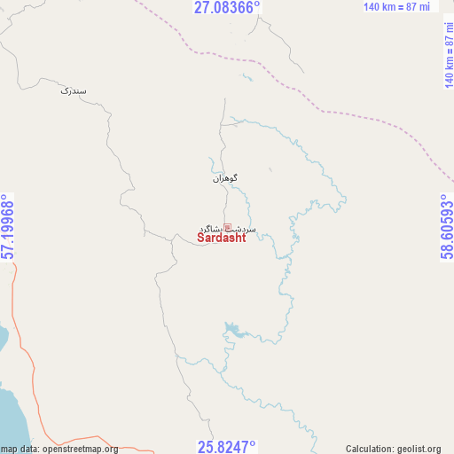
Sardasht GPS coordinates[2]
26° 27' 21.24" North, 57° 54' 10.08" East
| Map corner | latitude | longitude |
|---|---|---|
| Upper-left | 27.08366°, | 57.19968° |
| Center: | 26.4559°, | 57.9028° |
| Lower-right: | 25.8247°, | 58.60593° |
| Map W x H: | 140×140 km | = 87×87mi |
| max Lat: | 39.6482° ⇑98.6% North |
| Sardasht: | 26.4559° |
| min Lat: | ⇓1.4% South 25.2919° |
| min Long | Sardasht | max Long |
| 44.38416° | 57.9028° | 61.9965° |
| W 87.5%⇐ | ⇒12.5% E |
Elevation
Elevation of Sardasht is 727 m = 2385 ft, and this is 322 m = 1056 ft below average elevation for this country.
| Max E: |
2564 m = 8412 ft | 68.5% |
| Avg. | 1049 m = 3442 ft | |
| Sardasht | 727 m = 2385 ft | |
Min E: |
-24 m = -79 ft | 31.5% |
See also: Iran elevation on elevation.city.
Geographical zone
Sardasht is located in North temperate zone (between Tropic of Cancer and the Arctic Circle). Distance of this Northern Tropic circle is 335.7 km =208.6 mi to South.| Distance of | km | miles | from Sardasht |
|---|---|---|---|
| North Pole | 7065.4 | 4390.2 | to North |
| Arctic Circle | 4459.6 | 2771.1 | to North |
| Tropic Cancer | 335.7 | 208.6 | to South |
| Equator | 2941.6 | 1827.8 | to South |


Nearby cities:
15 places around Sardasht: (largest is in red/bold)
• Bandar Abbas
180.3 km =112 mi,  296°
296°
• Bandar-e Khamīr
236.7 km =147.1 mi,  283°
283°
• Dalgān
190.9 km =118.6 mi,  53°
53°
• Eslāmābād
174.9 km =108.7 mi,  3°
3°
• Fannūj
173.3 km =107.7 mi,  85°
85°
• Fāryāb
194.3 km =120.7 mi,  340°
340°
• Jask
91 km =56.5 mi,  188°
188°
• Kahnūj
167.5 km =104.1 mi,  353°
353°
• Manūjān
113 km =70.2 mi, 339°
• Mīnāb
110.4 km =68.6 mi,  312°
312°
• Nīkshahr
231.7 km =144 mi,  96°
96°
• Qal‘eh Ganj
118.7 km =73.8 mi,  358°
358°
• Qeshm
171.3 km =106.4 mi,  288°
288°
• Rūdān
130.3 km =81 mi,  327°
327°
• ‘Anbarābād
224.7 km =139.6 mi, 358°
Sources, notices
• [Note1] Compared only with cities in Iran existing in our database
• [Src1] Map data: © OpenStreetMap contributors (CC-BY-SA)
• [Src2] Other city data from geonames.org with taken over terms of usage.
• [Src3] Geographical zone / Annual Mean Temperature by Robert A. Rohde @ Wikipedia
