Bandar Abbas geodata
Bandar Abbas (Hormozgan) is a seat of a first-order administrative division; located in Iran in Asia/Tehran (GMT+3.5) time zone. With population of 352,173 people, there are 22 cities with bigger population in this country. Compared to other cities in Iran, 96.8% of cities are located further ↑North; 80.7% of cities are located further ←West and 92.3% of cities have higher elevation than Bandar Abbas. Note1


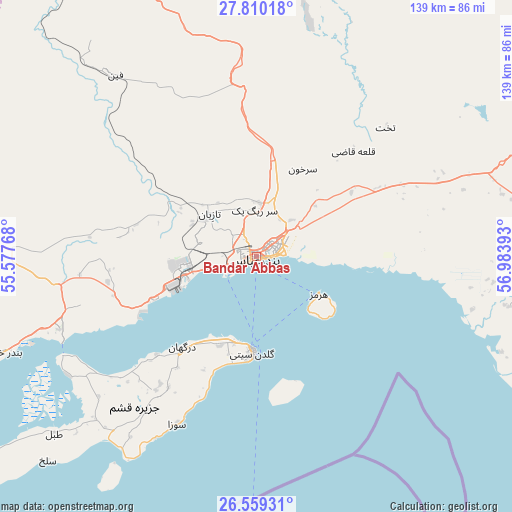
Bandar Abbas GPS coordinates[2]
27° 11' 11.4" North, 56° 16' 50.88" East
| Map corner | latitude | longitude |
|---|---|---|
| Upper-left | 27.81018°, | 55.57768° |
| Center: | 27.1865°, | 56.2808° |
| Lower-right: | 26.55931°, | 56.98393° |
| Map W x H: | 139.1×139.1 km | = 86.4×86.4mi |
| max Lat: | 39.6482° ⇑96.8% North |
| Bandar Abbas: | 27.1865° |
| min Lat: | ⇓3.2% South 25.2919° |
| min Long | Bandar Abbas | max Long |
| 44.38416° | 56.2808° | 61.9965° |
| W 80.7%⇐ | ⇒19.3% E |
Elevation
Elevation of Bandar Abbas is 9 m = 30 ft, and this is 1040 m = 3412 ft below average elevation for this country.
| Max E: |
2564 m = 8412 ft | 92.3% |
| Avg. | 1049 m = 3442 ft | |
| Bandar Abbas | 9 m = 30 ft | |
Min E: |
-24 m = -79 ft | 7.7% |
See also: Bandar Abbas elevation on elevation.city.
Geographical zone
Bandar Abbas is located in North temperate zone (between Tropic of Cancer and the Arctic Circle). Distance of this Northern Tropic circle is 416.9 km =259 mi to South.| Distance of | km | miles | from Bandar Abbas |
|---|---|---|---|
| North Pole | 6984.2 | 4339.8 | to North |
| Arctic Circle | 4378.3 | 2720.5 | to North |
| Tropic Cancer | 416.9 | 259 | to South |
| Equator | 3022.9 | 1878.3 | to South |


Nearby cities:
15 places around Bandar Abbas: (largest is in red/bold)
• Arzū’īyeh
139.8 km =86.9 mi,  3°
3°
• Bandar-e Khamīr
73.6 km =45.7 mi,  249°
249°
• Bandar-e Lengeh
155.5 km =96.6 mi,  243°
243°
• Bastak
189.3 km =117.6 mi,  270°
270°
• Eslāmābād
193.4 km =120.2 mi,  61°
61°
• Fāryāb
138.1 km =85.8 mi,  42°
42°
• Kahnūj
163.7 km =101.7 mi, 58°
• Manūjān
123.1 km =76.5 mi,  78°
78°
• Mīnāb
80 km =49.7 mi,  94°
94°
• Qal‘eh Ganj
162.4 km =100.9 mi, 76°
• Qeshm
26.4 km =16.4 mi,  182°
182°
• Rūdān
94.4 km =58.7 mi,  72°
72°
• Sardasht
180.3 km =112 mi,  116°
116°
• Shahr-e Qadīm-e Lār
199.2 km =123.8 mi,  286°
286°
• Ḩājjīābād
130.3 km =81 mi,  343°
343°
Sources, notices
• [Note1] Compared only with cities in Iran existing in our database
• [Src1] Map data: © OpenStreetMap contributors (CC-BY-SA)
• [Src2] Other city data from geonames.org with taken over terms of usage.
• [Src3] Geographical zone / Annual Mean Temperature by Robert A. Rohde @ Wikipedia
