Qeshm geodata
Qeshm (Hormozgan) is a seat of a second-order administrative division; located in Iran in Asia/Tehran (GMT+3.5) time zone. With population of 25,000 people, there are 186 cities with bigger population in this country. Compared to other cities in Iran, 97.7% of cities are located further ↑North; 80.5% of cities are located further ←West and 86.8% of cities have higher elevation than Qeshm. Note1


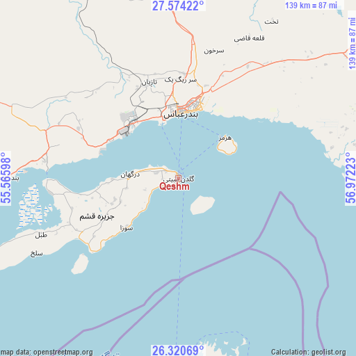
Qeshm GPS coordinates[2]
26° 56' 57.12" North, 56° 16' 8.76" East
| Map corner | latitude | longitude |
|---|---|---|
| Upper-left | 27.57422°, | 55.56598° |
| Center: | 26.9492°, | 56.2691° |
| Lower-right: | 26.32069°, | 56.97223° |
| Map W x H: | 139.4×139.4 km | = 86.6×86.6mi |
| max Lat: | 39.6482° ⇑97.7% North |
| Qeshm: | 26.9492° |
| min Lat: | ⇓2.3% South 25.2919° |
| min Long | Qeshm | max Long |
| 44.38416° | 56.2691° | 61.9965° |
| W 80.5%⇐ | ⇒19.5% E |
Elevation
Elevation of Qeshm is 34 m = 112 ft, and this is 1015 m = 3330 ft below average elevation for this country.
| Max E: |
2564 m = 8412 ft | 86.8% |
| Avg. | 1049 m = 3442 ft | |
| Qeshm | 34 m = 112 ft | |
Min E: |
-24 m = -79 ft | 13.2% |
See also: Iran elevation on elevation.city.
Geographical zone
Qeshm is located in North temperate zone (between Tropic of Cancer and the Arctic Circle). Distance of this Northern Tropic circle is 390.6 km =242.7 mi to South.| Distance of | km | miles | from Qeshm |
|---|---|---|---|
| North Pole | 7010.6 | 4356.2 | to North |
| Arctic Circle | 4404.7 | 2737 | to North |
| Tropic Cancer | 390.6 | 242.7 | to South |
| Equator | 2996.5 | 1861.9 | to South |


Nearby cities:
15 places around Qeshm: (largest is in red/bold)
• Arzū’īyeh
166.2 km =103.3 mi,  3°
3°
• Bandar Abbas
26.4 km =16.4 mi, 2°
• Bandar-e Khamīr
67.8 km =42.1 mi,  270°
270°
• Bandar-e Lengeh
144.6 km =89.9 mi,  252°
252°
• Bastak
190.4 km =118.3 mi,  278°
278°
• Eslāmābād
208.5 km =129.6 mi,  54°
54°
• Fāryāb
159.2 km =98.9 mi,  36°
36°
• Kahnūj
179.9 km =111.8 mi, 51°
• Manūjān
132.1 km =82.1 mi,  67°
67°
• Mīnāb
83.5 km =51.9 mi,  75°
75°
• Qal‘eh Ganj
171.7 km =106.7 mi, 68°
• Rūdān
106.5 km =66.2 mi,  59°
59°
• Sardasht
171.3 km =106.4 mi,  108°
108°
• Shahr-e Qadīm-e Lār
207.2 km =128.7 mi,  293°
293°
• Ḩājjīābād
155.5 km =96.6 mi,  346°
346°
Sources, notices
• [Note1] Compared only with cities in Iran existing in our database
• [Src1] Map data: © OpenStreetMap contributors (CC-BY-SA)
• [Src2] Other city data from geonames.org with taken over terms of usage.
• [Src3] Geographical zone / Annual Mean Temperature by Robert A. Rohde @ Wikipedia
