Kahnūj geodata
Kahnūj (Kerman) is a seat of a second-order administrative division; located in Iran in Asia/Tehran (GMT+3.5) time zone. In our database, there are 232 cities with bigger population. Compared to other cities in Iran, 92.7% of cities are located further ↑North; 86.4% of cities are located further ←West and 73% of cities have higher elevation than Kahnūj. Note1


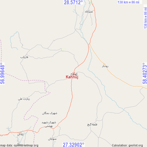
Kahnūj GPS coordinates[2]
27° 57' 6.84" North, 57° 41' 58.56" East
| Map corner | latitude | longitude |
|---|---|---|
| Upper-left | 28.5712°, | 56.99648° |
| Center: | 27.9519°, | 57.6996° |
| Lower-right: | 27.32902°, | 58.40273° |
| Map W x H: | 138.1×138.1 km | = 85.8×85.8mi |
| max Lat: | 39.6482° ⇑92.7% North |
| Kahnūj: | 27.9519° |
| min Lat: | ⇓7.3% South 25.2919° |
| min Long | Kahnūj | max Long |
| 44.38416° | 57.6996° | 61.9965° |
| W 86.4%⇐ | ⇒13.6% E |
Elevation
Elevation of Kahnūj is 505 m = 1657 ft, and this is 544 m = 1785 ft below average elevation for this country.
| Max E: |
2564 m = 8412 ft | 73% |
| Avg. | 1049 m = 3442 ft | |
| Kahnūj | 505 m = 1657 ft | |
Min E: |
-24 m = -79 ft | 27% |
See also: Iran elevation on elevation.city.
Geographical zone
Kahnūj is located in North temperate zone (between Tropic of Cancer and the Arctic Circle). Distance of this Northern Tropic circle is 502 km =311.9 mi to South.| Distance of | km | miles | from Kahnūj |
|---|---|---|---|
| North Pole | 6899.1 | 4286.9 | to North |
| Arctic Circle | 4293.2 | 2667.7 | to North |
| Tropic Cancer | 502 | 311.9 | to South |
| Equator | 3108 | 1931.2 | to South |


Nearby cities:
15 places around Kahnūj: (largest is in red/bold)
• Arzū’īyeh
141 km =87.6 mi,  292°
292°
• Bam
143.5 km =89.2 mi,  26°
26°
• Bandar Abbas
163.7 km =101.7 mi,  238°
238°
• Eslāmābād
30.6 km =19 mi,  74°
74°
• Fahraj
160.5 km =99.7 mi,  46°
46°
• Fāryāb
48.7 km =30.3 mi, 289°
• Jīroft
80.8 km =50.2 mi,  2°
2°
• Manūjān
63.7 km =39.6 mi,  197°
197°
• Moḩammadābād
156.3 km =97.1 mi,  59°
59°
• Mīnāb
109.4 km =68 mi,  213°
213°
• Narmāshīr
148 km =92 mi,  41°
41°
• Qal‘eh Ganj
50.9 km =31.6 mi,  159°
159°
• Rūdān
75.6 km =47 mi,  221°
221°
• Sardasht
167.5 km =104.1 mi,  173°
173°
• ‘Anbarābād
60.1 km =37.3 mi,  14°
14°
Sources, notices
• [Note1] Compared only with cities in Iran existing in our database
• [Src1] Map data: © OpenStreetMap contributors (CC-BY-SA)
• [Src2] Other city data from geonames.org with taken over terms of usage.
• [Src3] Geographical zone / Annual Mean Temperature by Robert A. Rohde @ Wikipedia
