Nīkshahr geodata
Nīkshahr (Sistan and Baluchestan) is a seat of a second-order administrative division; located in Iran in Asia/Tehran (GMT+3.5) time zone. With population of 17,000 people, there are 199 cities with bigger population in this country. Compared to other cities in Iran, 99.3% of cities are located further ↑North; 96.4% of cities are located further ←West and 74.4% of cities have higher elevation than Nīkshahr. Note1


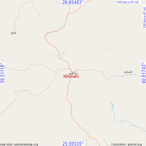
Nīkshahr GPS coordinates[2]
26° 13' 32.88" North, 60° 12' 51.48" East
| Map corner | latitude | longitude |
|---|---|---|
| Upper-left | 26.85483°, | 59.51118° |
| Center: | 26.2258°, | 60.2143° |
| Lower-right: | 25.59335°, | 60.91743° |
| Map W x H: | 140.3×140.3 km | = 87.2×87.2mi |
| max Lat: | 39.6482° ⇑99.3% North |
| Nīkshahr: | 26.2258° |
| min Lat: | ⇓0.7% South 25.2919° |
| min Long | Nīkshahr | max Long |
| 44.38416° | 60.2143° | 61.9965° |
| W 96.4%⇐ | ⇒3.6% E |
Elevation
Elevation of Nīkshahr is 466 m = 1529 ft, and this is 583 m = 1913 ft below average elevation for this country.
| Max E: |
2564 m = 8412 ft | 74.4% |
| Avg. | 1049 m = 3442 ft | |
| Nīkshahr | 466 m = 1529 ft | |
Min E: |
-24 m = -79 ft | 25.6% |
See also: Iran elevation on elevation.city.
Geographical zone
Nīkshahr is located in North temperate zone (between Tropic of Cancer and the Arctic Circle). Distance of this Northern Tropic circle is 310.1 km =192.7 mi to South.| Distance of | km | miles | from Nīkshahr |
|---|---|---|---|
| North Pole | 7091 | 4406.1 | to North |
| Arctic Circle | 4485.1 | 2786.9 | to North |
| Tropic Cancer | 310.1 | 192.7 | to South |
| Equator | 2916 | 1811.9 | to South |


Nearby cities:
15 places around Nīkshahr: (largest is in red/bold)
• Chabahar
112.4 km =69.8 mi,  157°
157°
• Dalgān
159.1 km =98.9 mi,  331°
331°
• Eslāmābād
296.8 km =184.4 mi,  312°
312°
• Fannūj
69.2 km =43 mi,  304°
304°
• Iranshahr
118.2 km =73.4 mi,  23°
23°
• Jask
252.2 km =156.7 mi,  255°
255°
• Khāsh
242.9 km =150.9 mi, 24°
• Konārak
98 km =60.9 mi,  169°
169°
• Moḩammadābād
294 km =182.7 mi,  337°
337°
• Qal‘eh Ganj
272.7 km =169.4 mi, 301°
• Qaşr-e Qand
53.7 km =33.4 mi,  87°
87°
• Rāsak
118.2 km =73.4 mi, 89°
• Sardasht
231.7 km =144 mi,  276°
276°
• Sūrān
212.6 km =132.1 mi,  56°
56°
• Zābolī
176.6 km =109.7 mi, 55°
Sources, notices
• [Note1] Compared only with cities in Iran existing in our database
• [Src1] Map data: © OpenStreetMap contributors (CC-BY-SA)
• [Src2] Other city data from geonames.org with taken over terms of usage.
• [Src3] Geographical zone / Annual Mean Temperature by Robert A. Rohde @ Wikipedia
