Manūjān geodata
Manūjān (Kerman) is a seat of a second-order administrative division; located in Iran in Asia/Tehran (GMT+3.5) time zone. In our database, there are 232 cities with bigger population. Compared to other cities in Iran, 95.5% of cities are located further ↑North; 85.7% of cities are located further ←West and 76.9% of cities have higher elevation than Manūjān. Note1


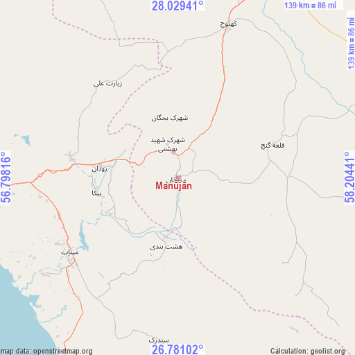
Manūjān GPS coordinates[2]
27° 24' 25.128" North, 57° 30' 4.608" East
| Map corner | latitude | longitude |
|---|---|---|
| Upper-left | 28.02941°, | 56.79816° |
| Center: | 27.40698°, | 57.50128° |
| Lower-right: | 26.78102°, | 58.20441° |
| Map W x H: | 138.8×138.8 km | = 86.2×86.2mi |
| max Lat: | 39.6482° ⇑95.5% North |
| Manūjān: | 27.40698° |
| min Lat: | ⇓4.5% South 25.2919° |
| min Long | Manūjān | max Long |
| 44.38416° | 57.50128° | 61.9965° |
| W 85.7%⇐ | ⇒14.3% E |
Elevation
Elevation of Manūjān is 345 m = 1132 ft, and this is 704 m = 2310 ft below average elevation for this country.
| Max E: |
2564 m = 8412 ft | 76.9% |
| Avg. | 1049 m = 3442 ft | |
| Manūjān | 345 m = 1132 ft | |
Min E: |
-24 m = -79 ft | 23.1% |
See also: Iran elevation on elevation.city.
Geographical zone
Manūjān is located in North temperate zone (between Tropic of Cancer and the Arctic Circle). Distance of this Northern Tropic circle is 441.5 km =274.3 mi to South.| Distance of | km | miles | from Manūjān |
|---|---|---|---|
| North Pole | 6959.7 | 4324.6 | to North |
| Arctic Circle | 4353.8 | 2705.3 | to North |
| Tropic Cancer | 441.5 | 274.3 | to South |
| Equator | 3047.4 | 1893.6 | to South |


Nearby cities:
15 places around Manūjān: (largest is in red/bold)
• Arzū’īyeh
159.7 km =99.2 mi,  316°
316°
• Bandar Abbas
123.1 km =76.5 mi,  258°
258°
• Bandar-e Khamīr
196.2 km =121.9 mi, 255°
• Dalgān
192.1 km =119.4 mi,  87°
87°
• Eslāmābād
84.6 km =52.6 mi,  35°
35°
• Fāryāb
81.4 km =50.6 mi,  340°
340°
• Jīroft
143.3 km =89 mi,  9°
9°
• Kahnūj
63.7 km =39.6 mi,  17°
17°
• Mīnāb
51.2 km =31.8 mi,  233°
233°
• Qal‘eh Ganj
39.7 km =24.7 mi,  70°
70°
• Qeshm
132.1 km =82.1 mi,  247°
247°
• Rūdān
30.8 km =19.1 mi,  277°
277°
• Sardasht
113 km =70.2 mi,  159°
159°
• Ḩājjīābād
186.5 km =115.9 mi,  302°
302°
• ‘Anbarābād
123.6 km =76.8 mi, 15°
Sources, notices
• [Note1] Compared only with cities in Iran existing in our database
• [Src1] Map data: © OpenStreetMap contributors (CC-BY-SA)
• [Src2] Other city data from geonames.org with taken over terms of usage.
• [Src3] Geographical zone / Annual Mean Temperature by Robert A. Rohde @ Wikipedia
